For folks like Margaret Smith, spring in Memphis is a brief window
upon a fantastic world.
 Tennessee Trails Association
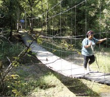
Village Creek
“Right now is the perfect time for hiking,” says Smith, president of
the Memphis chapter of the Tennessee Trails Association. “The flowers
are coming out, the dogwood is in bloom. In summer, of course, it’s too
hot and humid to get out there.”
That’s why this is the busiest time of year for the Trails
Association, whose Memphis chapter has about 70 members and a hiking
season that runs from September through May.
We decided to ask Smith about some of her favorite destinations
within a couple hours of town. Consider this a primer for getting out
while the getting out is still good.
The place: Meeman-Shelby Forest State Park.
The hike: Try the eight-mile Chickasaw Bluff Trail, with good
views of the Mississippi River and some nice ups and downs. “A good
hike to get your heart going, and there are a lot of flowers there,”
Smith says. If eight miles sounds a bit much, there are plenty of other
options, with a total of 20 trail miles available, including some in
the bottoms along the river.
Getting there: About 15 miles north of Memphis, just off
Highway 51.
More info: Call the park at 876-5215 or 800-471-5293.
The place: Wolf River Wildlife Area.
The hike: A mostly level ramble along the Wolf through a lush
forest filled with sycamore trees. Keep an eye out for deer and wild
turkeys, as well as river otters. This is a new wildlife area
designated in the fall of 2008 and remains relatively unknown.
Getting there: Located on the north bank of the Wolf north of
Collierville, between Collierville-Arlington and Houston Levee roads.
One access point is a road leading down to the river from the north
side of the Collierville-Arlington Road bridge over the Wolf.
The place: Herb Parsons Lake in Fisherville.
The hike: A forested, easy, six-mile loop around the lake,
with some small hills but ever-changing scenery and plenty of places to
stop for a lakeside picnic lunch. Start your hike along the levee to
the right of park, and keep an eye out for one spot where you have to
leave the trail for a road briefly. This one is popular with mountain
bikers, as well.
Getting there: From I-40, take Exit 25 (Hwy. 205) south to
Highway 193. Turn left on 193, then turn right on Fisherville Lake Road
to the entrance.
More info: Call 861-5087.
The place: Lucius Burch State Natural Area.
The hike: Options abound in this 700-acre natural area, which
is part of 6,000-acre Shelby Farms County Park. The state Division of
Natural Areas says it’s “a remnant of historic river meanders, bald
cypress-water tupelo swamps, bottomland hardwood forests, and open
river channel habitat. It provides a refuge for forest dwelling birds,
mammals, reptiles, and amphibians.”
Getting there: Access is off Walnut Grove Road across from
Patriot Lake.
More info: Contact Shelby Farms Park (382-0235) for a
detailed map and directions.
The place: Village Creek State Park near Wayne, Arkansas.
The hike: The park sits on Crowley’s Ridge, which is covered
with a lush hardwood forest featuring oak, sugar maple, beech,
butternut, and tulip poplar. A favorite hike of the TTA is the Military
Road Trail, which is 2.4 miles in length and rated as moderate in
difficulty. It preserves the most dramatic remaining portion of the
Trail of Tears, completed in 1829. Other trails include the 2.75-mile
Lake Dunn Trail and several shorter nature trails.
Getting there: Take Exit #242 off I-40 at Forrest City, about
an hour west of Memphis. From there, go 13 miles north on AR 284 to the
park.
More info: Call the park at 870-238-9406.