Categories
News The Fly-By

“Old Bridge” Closure Could Pinch Memphis

Predictions of the consequences from the planned, nine-months closure of the Memphis-Arkansas Bridge range from inconvenient to nightmarish, but a Tennessee Department of Transportation (TDOT) official said there was simply no other way.

Speculation and worry followed last week’s announcement that TDOT plans to close the bridge while it builds a new interchange at I-55 and E.H. Crump. A public meeting about the project was held in West Memphis Monday. Another meeting is scheduled for 4 p.m. Thursday at Memphis Area Transit Authority Central Station. 

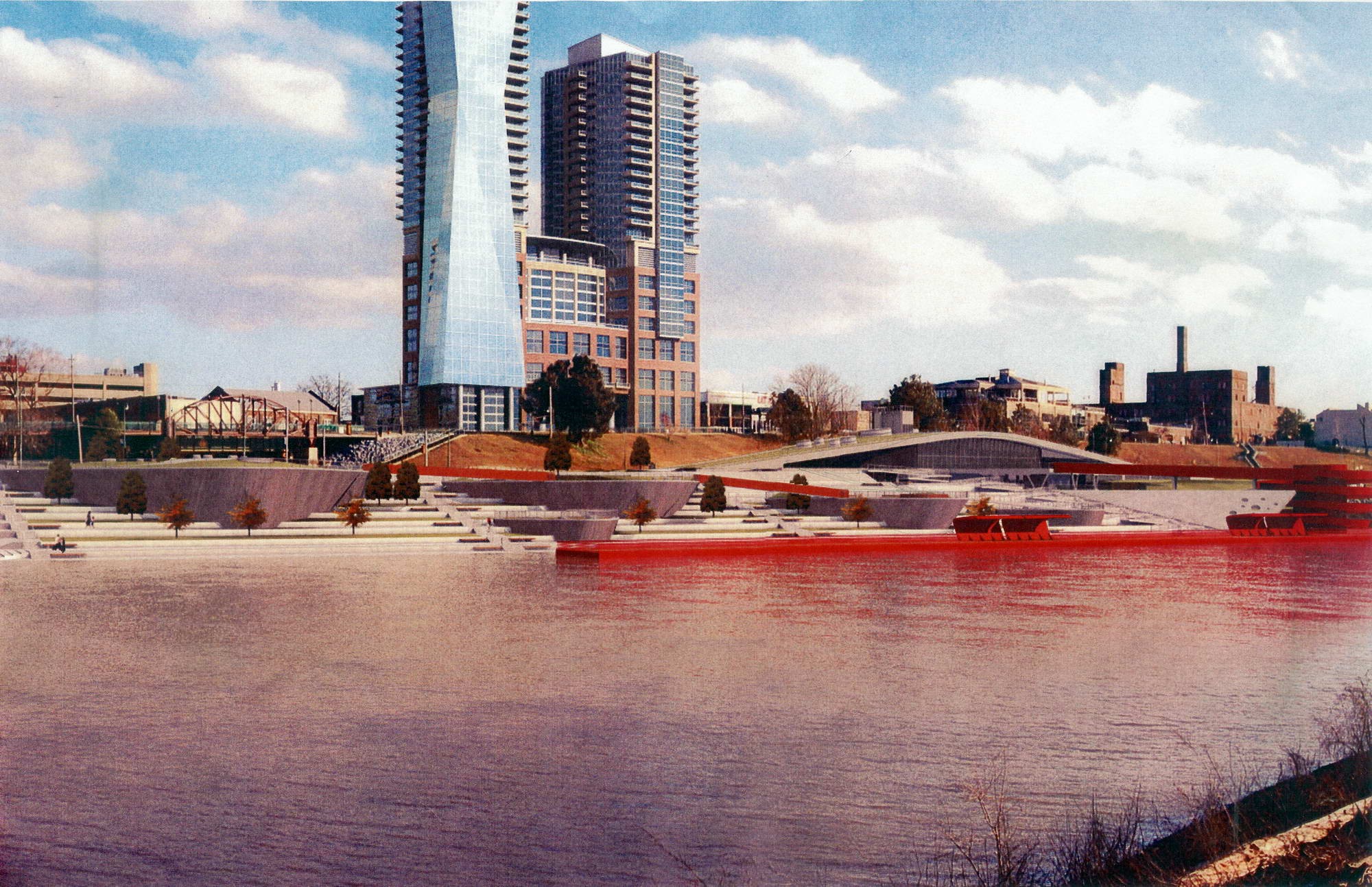
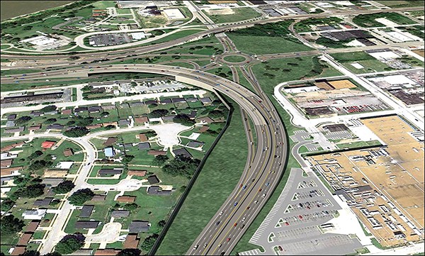
The project will cost close to $35 million and will replace the current cloverleaf design of the interchange, which TDOT calls “outdated,” claiming it poses safety and efficiency concerns. The new design will feature a roundabout to connect I-55 traffic to downtown Memphis and curved ramps to allow I-55 thru traffic to continue on and off the bridge without slowing down.

Courtesy TDOT

An artists rendering of the proposed new interchange at I-55 and Crump.

The three-year construction project won’t begin until spring 2016 and the planned closure of the bridge won’t begin until spring 2017, said B.J. Doughty, TDOT communications director. 

“We do not take this lightly; this is a major undertaking for us, as well,” Doughty said. “If there had been any other way … we would choose not to shut it down. We realize this is an enormous inconvenience for people.”

The long curved ramps to I-55 will be built over the roundabout, where the cloverleaf is now, Doughty said. To make way for big bridge pieces like beams and piers, there will be no place for traffic to pass, she said.

During construction, all I-55 traffic will have to be routed across the Hernando DeSoto M Bridge, and that has people worried.

Manny Belen, deputy engineer for the city of Memphis, said his office has expressed to TDOT that the project needs to be sensitive to the impact on businesses, commuters, downtown residents, freight movement, and emergency responders. 

“Additionally, we’ve expressed concerns about the impact of the planned detour through the Midtown section of I-240 and the inevitable traffic congestion,” Belen said. “The response from TDOT is that this nine-months closure is the most prudent direction and the least impactful.”

Congressman Steve Cohen said he does not support the planned closure and believes the construction can be accomplished without closing the bridge. At a minimum, he said, any closure period should be expedited.

Paul Morris, president of the Downtown Memphis Commission, called the planned closure “painful,” but its results will dramatically improve the approach to downtown Memphis and reconnect the French Fort neighborhood to downtown.

“I certainly wish there were a way for them to do the work without closing the bridge, which is going to be very bad for downtown and West Memphis,” Morris said. “This is little comfort, but we will have the Big River Crossing over the Harahan open by the time of the closure, meaning that it will be easier to bike rather than drive across the Mississippi River.”

If the bridge is closed as TDOT plans, I-55 traffic would be diverted to I-240 through Midtown, up to I-40 and across the Hernando DeSoto Bridge. Doughty said TDOT plans to work closely with local law enforcement and emergency services to keep traffic running efficiently in case of an accident.

Doughty said TDOT closed a section of I-40 close to downtown Knoxville in 2008, and the project went “incredibly smoothly.”

Categories
Letters To The Editor Opinion

What They Said (November 27, 2014)…

Greg Cravens

About Toby Sells’ story, “West Memphis Plans for Big River Crossing”…

The exhibit will include a trailer park, a working Walmart, and real live tornado damage.

Jeff

About Wendi C. Thomas’ column, “Bicycle Bias”…

This is what the discussion on bicycles has boiled down to? Race?

CL_Mullins

About the continuing lack of trolleys downtown …

How can the lack of trolleys be such an accepted reality. We live in South Main and enjoyed hopping the trolley to a variety of locations on the route. We were frequent visitors to Mulligan’s in the Pinch and to ballgames at AutoZone Park via transportation provided by the trolley system. Without these trolleys, downtown takes a step back. The trolley line is the spinal cord of the entire downtown experience. It is especially needed as Bass Pro Shops gets closer to opening.

Please get them back up and running, even if service is limited; buses are not the same. Five trolleys running the river loop with a GPS app letting you know where they are, will bring them — and downtown — back into the limelight they both should enjoy.

Steve Stoerger

About Louis Goggan’s story, “So Far, So Smart” …

Long-time politician Ian Randolph says he likes smart meters because he is able to track his use of electricity better. However, the IBEW Local 1288 Union of Memphis Light, Gas, and Water, says, “Smart meters can identify which appliance is drawing current, but the utilities only show your total usage online, not the itemized cost of each appliance.”

How are you going to lower your costs if you don’t know which appliance is drawing the most electricity? And what benefit is online information to seniors who have little involvement with computers?

MLGW President Jerry Collins says one of the advantages of smart meters is that meter readers will never have to come onto your property, and this will “give you a greater level of home security.” A smart meter is a computer. Bill Hawkins of the International Brotherhood of Electricians says a thief can pull in front of your home with a computer with specialized equipment and turn off your alarm and your utilities.

Meters can be remotely operated by MLGW, so that all the time that you are lowering your thermostat, the utility company can be increasing your meter’s rate of speed. The sole purpose of smart meters is for politicians to make money.

Carole Fincher

About Memphis’ pollution and its effect on asthma rates …

In 2014, Memphis ranked as the second-worst city for asthma, according to the Asthma and Allergy Foundation of America. While there are a myriad of asthma triggers, we know that a key trigger is ground-level ozone, which we have in abundance in Memphis. Did you know that the American Lung Association rated our ground-level ozone quality as an F? Not only does ground-level ozone trigger asthma attacks, it causes a host of other respiratory problems. Children unfairly bear this burden, due to their developing lungs. As a mom, this alarms me.  

As parents, we do everything to protect our children, but we can’t buy clean air for them. We have to fight for it, by raising our voices and letting our elected officials know that our children need protection. The Clean Power Plan will require reduction of air pollution from coal-fired power plants, which are a tremendous contributor to the formation of ozone. Join me in telling Senator Alexander and Senator Corker that we insist on clean air for our children’s health by supporting the Clean Power Plan!

Lindsay Pace

Categories
Editorial Opinion

Downtown Memphis: Less is More

An early proposed version of Beale Street Landing.

The one thing Memphis and Shelby County have surely learned from the past decade or so, during which hard times visited and stayed around for a while, is that necessity truly is the mother of invention — and often a single mother at that. 

Even before the Great Crash of 2008-9, there was a general sense that we had let our ambitions on the development front soar a little too much. Take our riverfront: Organized opposition on the part of Friends of the River and other environmentally interested citizens was, along with alarms about the anticipated costs of the project, a major reason why some of the more ambitious iterations proposed by the Riverfront Development Corporation did not come to fruition. 

What was left on the plate was Beale Street Landing (BSL). Beset with delays, cost overruns, design controversies, and intermittent failures to cooperate by a sometimes unruly river, it finally got done within the past year. The public spaces are welcoming, the views are spectacular, and BSL has proved, if nothing else, to be a great place to have a party. The Flyer‘s own annual Best of Memphis celebration was held there to good effect earlier this year. 

It brings to mind the phrase — and the concept of — “less is more,” a term which, we discovered upon doing a little research, was originated not by the minimalist architect Mies van der Rohe, as was long supposed, but by Robert Browning in the British master’s 1855 poem, “Andrea del Sarto (Called ‘The Faultless Painter’).” 

We were stirred into admiration of a sort a few months back at an insight offered by Mayor A C Wharton (whom we had previously taken to desk, along with city planning maven Robert Lipscomb, for the grandiosity embedded in some of the ideas floated out of City Hall): Frustrated  by the scarcity of the times, by the drying up of public and private funding sources, and by overt warnings about fiscal over-reach from the state Comptroller’s office, Wharton offered a new, leaner version of development, which cast downtown Memphis as an open-air arena, with its parts — among them FedExForum, the National Civil Rights Museum, the soon-to-be Bass Pro Pyramid, and, yes, Beale Street Landing — being connected by relatively inexpensive public transportation. 

This was how the mayor saw us responding to tourist and convention competition from, say, Nashville, with its massive (and massively expensive) new Convention Center. 

“Less is more.” Yes, indeed. And even the nascent Main Street to Main Street Big Water Crossing project (aka Hanrahan Bridge project), establishing pedestrian connections between downtown and West Memphis, involves minimal transformation of existing natural surroundings at relatively low cost — the key component being a $14.9 million “Tiger Grant” from the federal government. Greg Maxted, the project’s executive director, made that modest but far-reaching project sing when he described its prospective glories to a luncheon meeting of the Rotary Club of Memphis on Tuesday. 

We have much to look forward to, and much of what is to come is already there, in a landscape that needs only some judicious tweaking, not a massive overhaul.

Categories
News The Fly-By

West Memphis Plans For Big River Crossing

When Big River Crossing is in the news, you can bet someone in Memphis will, again, call it the “bridge to nowhere.”

Construction began on the project last week, and officials said it will open in the spring or summer of 2016. 

Big River Crossing is the $17.5 million project that will transform part of the Harahan Bridge over the Mississippi River into a path for bicyclists and pedestrians. The Crossing is part of the 10-mile, $43 million Main Street to Main Street Multi-Modal Connector project that will create bike paths and walkways from Uptown Memphis to West Memphis, Arkansas.  

Calling the Crossing a “bridge to nowhere” is a two-sided insult. On one side, the slur means the Crossing is a boondoggle, a costly and unnecessary government infrastructure project. The other side is aimed directly at West Memphis. That the bike and pedestrian walkway will lead Memphians there implies that the small Arkansas town is “nowhere” or that there’s nothing for bikers or pedestrians to do when they get there. 

Before and after images of Big River Crossing

“We obviously know those comments,” said Jim Jackson, director of the West Memphis Office of Tourism. “We want to, and are working on, dispelling any of those.” 

Plans have been developed for an eco-park on the West Memphis side of the Crossing. The park would span the area between the bridges at I-55 and I-40, Jackson said. The plans feature a wildlife refuge, education spaces, trails along the river’s edge, and farming exhibits. If that’s not enough of a draw, Jackson is banking on at least one thing West Memphis has that Memphis doesn’t.  

“Everyone in Memphis can look toward us and see … a bean field,” Jackson said. “From our perspective looking back … it is a phenomenal view, looking at the Memphis skyline.” 

He said West Memphis and Arkansas are committed to making the Crossing a major attraction and pointed to Little Rock’s Big Dam Bridge, the longest bridge built for pedestrian and bicycle traffic in North America. But, he said, projects take money, and West Memphis and state officials are hard at work to find it for the Crossing.

Meanwhile, cyclists are already riding the levee tops around West Memphis along the Big River Parkway. That project’s backers want to open the Mississippi River levees up to bikers on a 660-mile trail from Memphis to New Orleans. 

National Geographic is working with those in the Big River Strategic Initiative to brand the parkway as a National Geographic geotourism destination. The society’s Center for Sustainable Destinations serves as a tour guide for people looking to travel to natural spaces. It has worked in the past with places like Greater Yellowstone, California’s Redwood Coast, and the East Tennessee River Valley.   

Back in July, board members of the St. Francis Levee District of Arkansas unanimously approved bikers on their 63-mile segment of the levee system. Bicyclists hit the trail in August on the first ever Big River Parkway Levee Ride that ran from West Memphis all the way to Marianna, Arkansas.