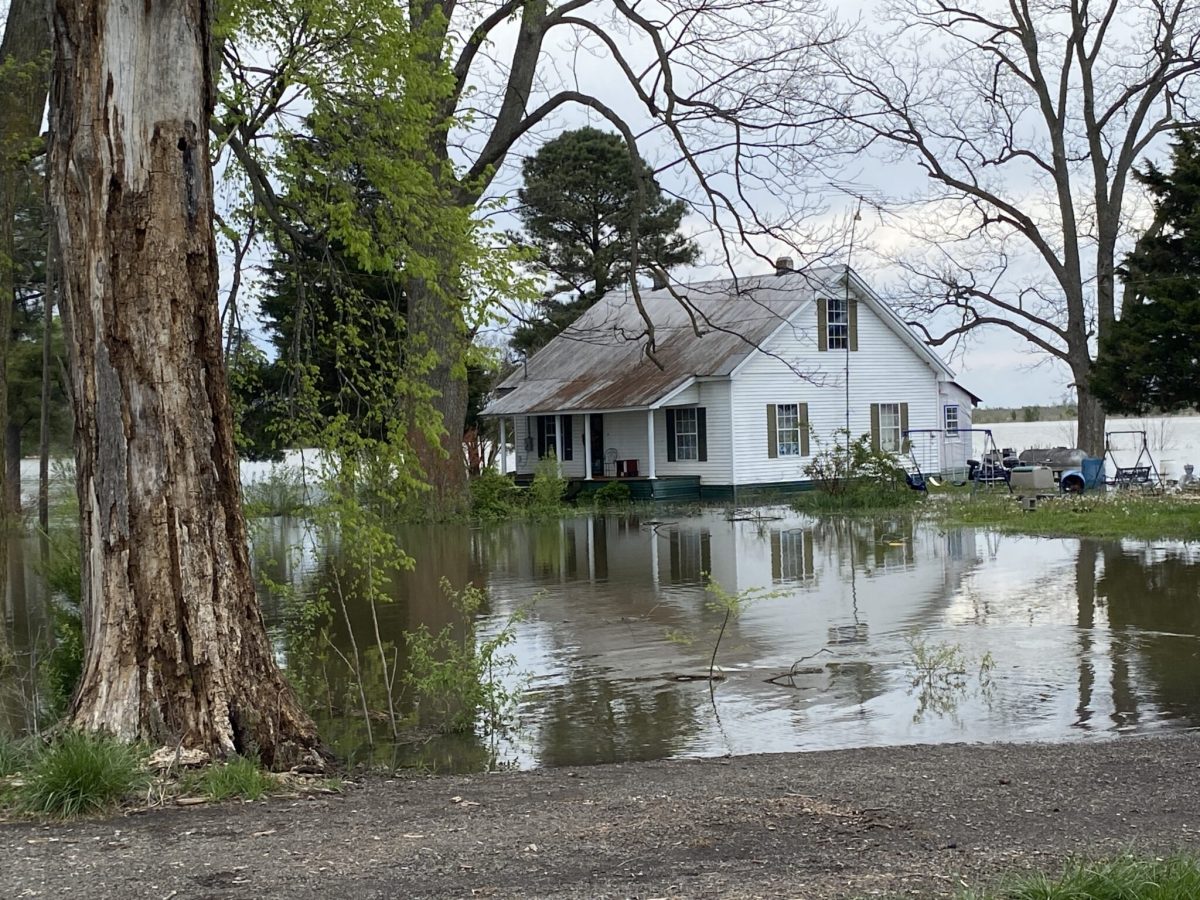
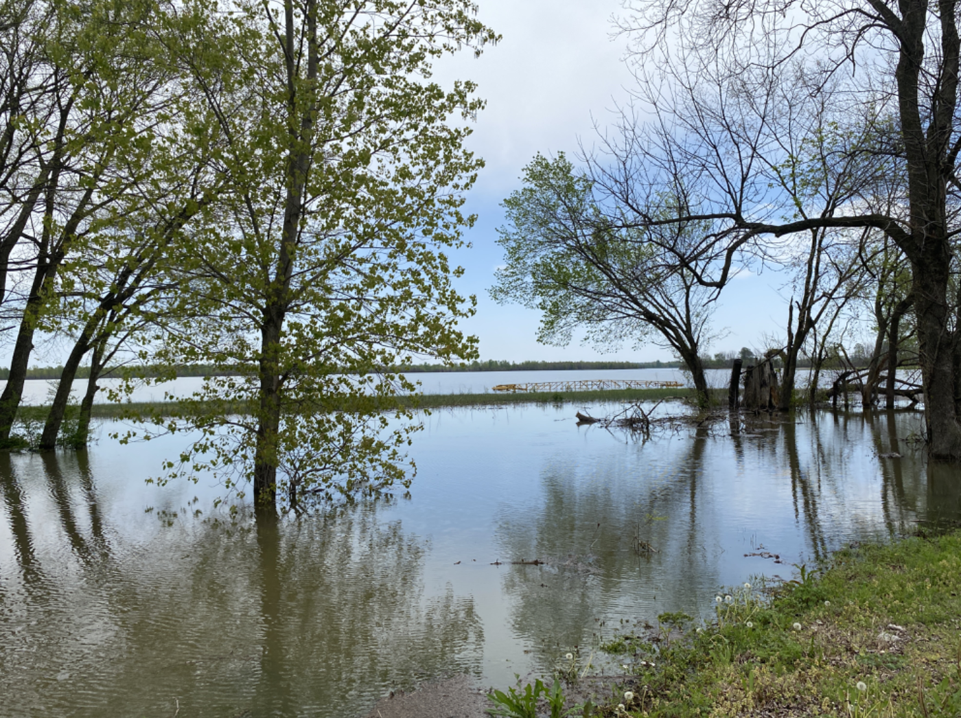
Flooding surrounds a house about a mile away from the Obion River in Ridgely, Tenn. on April 9, 2025 after 96 hours of torrential rain. (Photo: Cassandra Stephenson)
West Tennessee soybean farmers, already on the heels of a tough year, are now facing challenges posed by the remnants of early April floods.
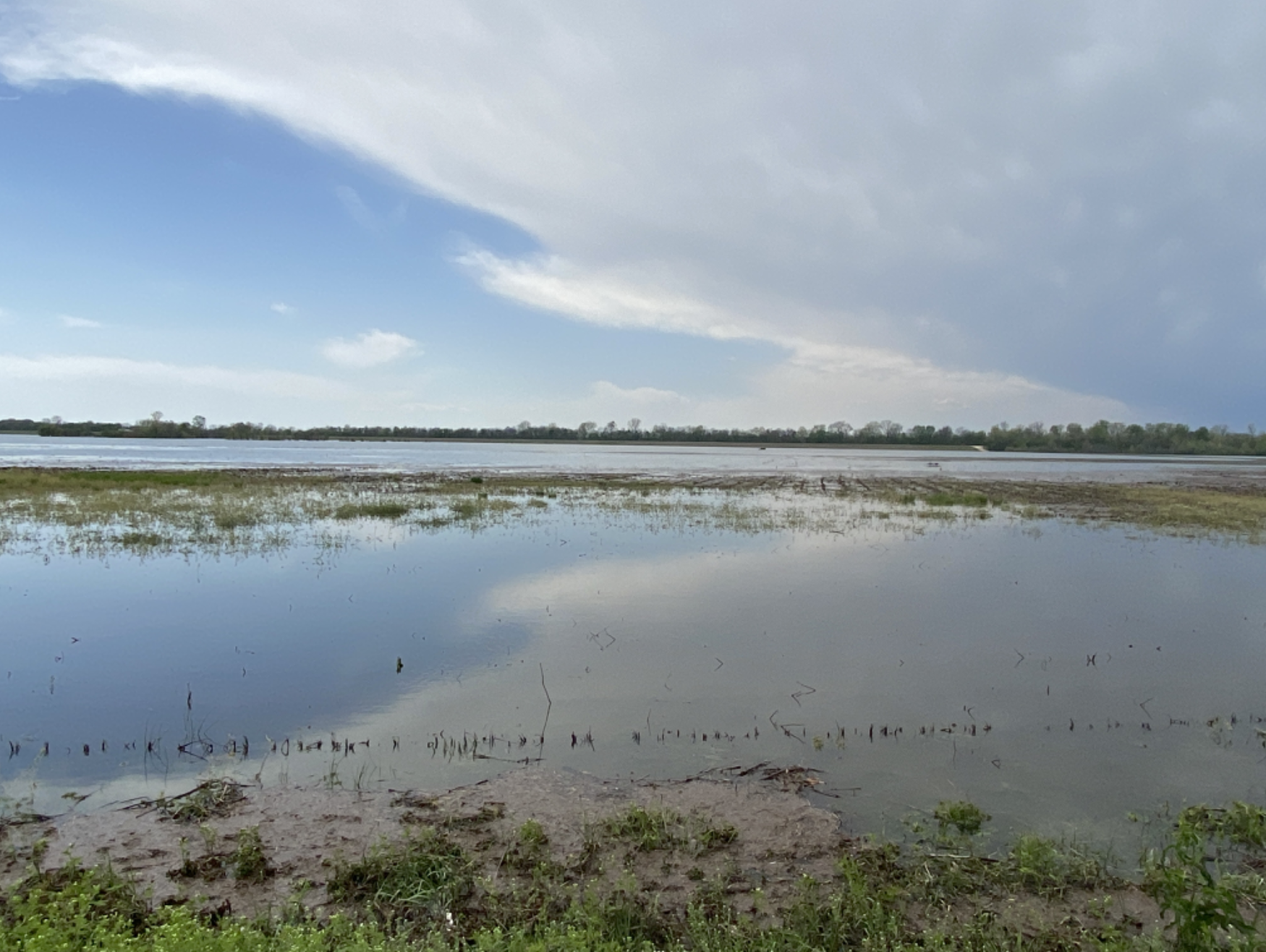
Gina Ward’s low-lying fields near Rives and the Obion River flooded in February, requiring the third-generation farm to make costly repairs to the private levee attached to their land.
Just a few weeks later, the majority of the levee was once again washed away in a near-record-setting flood after rain drenched Northwest Tennessee and surrounding areas.
The 96-hour rain event was the second-highest for the Obion, Forked Deer, and Loosahatchie Rivers, according to the U.S. Army Corps of Engineers.
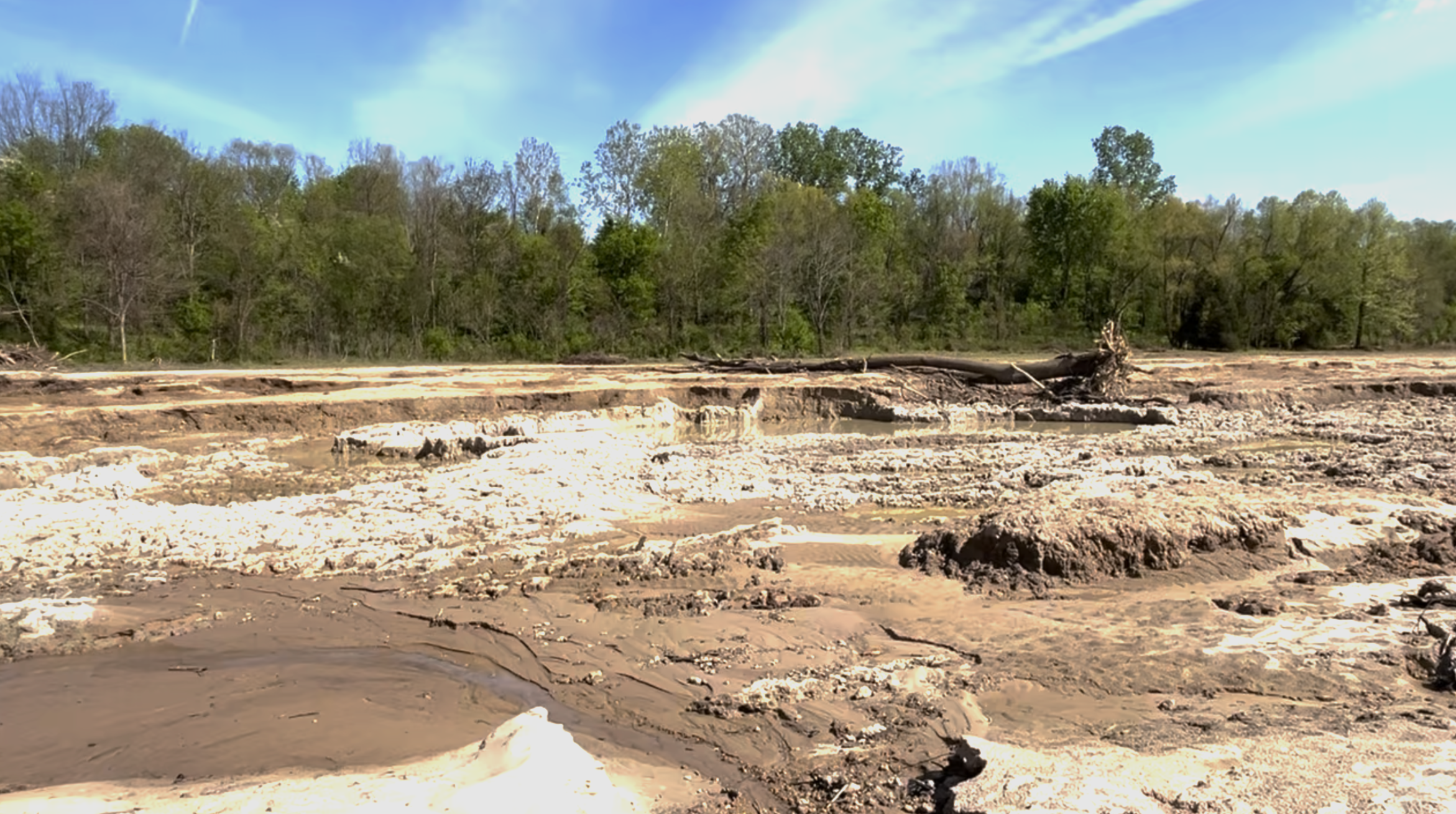
When the water finally began to recede from Ward’s drowned fields about 10 days later, it left craters and debris.
“It looks like the surface of the moon now,” she said.
Soybeans cover more acres than any other row crop in Tennessee, according to the University of Tennessee. The crop is most popular in the state’s west and central regions.
April typically marks the beginning of the planting season. Ward had not yet planted her fields when the storms began on April 3, but she wants to get seeds in the ground as soon as possible to maximize her yield.
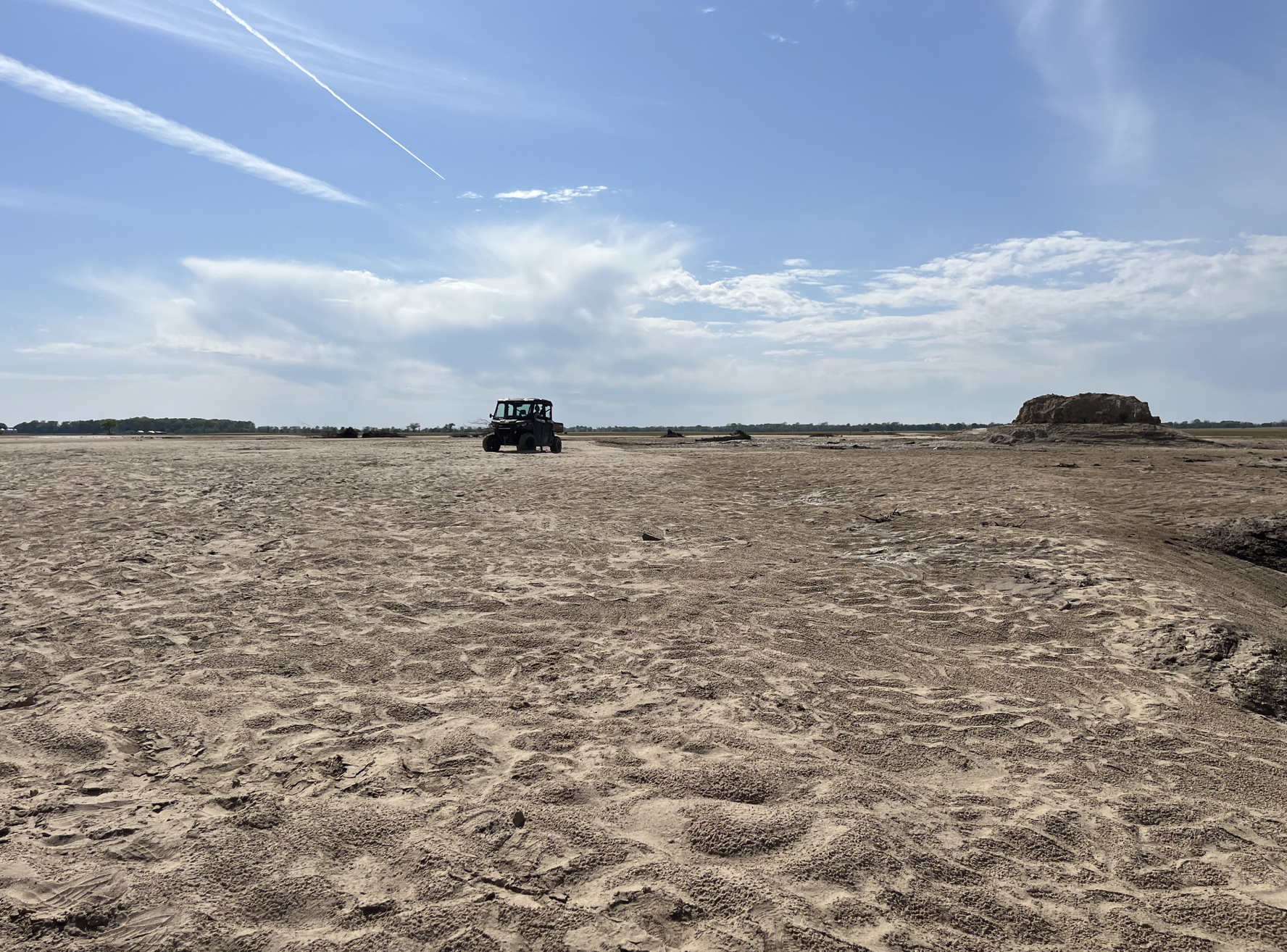
She has started planting in fields on higher ground. But the sandy moonscape left behind by the flood in lower-lying areas will take a lot of time and work before it’s ready to be planted again, Ward said.
Flood waters left deep ruts on portions of Gina Ward’s low-lying fields in Obion County near the Obion River. Ward said she had planned to plant soybeans on the land. (Photo: Gina Ward)Water from the overflowing Obion River covers a field on Owl Hoot Road in Ridgely, Tenn. on April 9, 2025. The field is about a mile away from the river’s typical bank. (Photo: Cassandra Stephenson)Craters covered the surface of Gina Ward’s field in Obion County near the Obion River after flood waters receded. (Photo: Gina Ward)Farm equipment is seen partially submerged on a flooded field in Ridgely, Tenn. on April 9, 2025. (Photo: Cassandra Stephenson)
“The farmers who farm that low-lying ground know that it’s best to wait as long as possible to get outside of flooding season before they start planting that ground,” he said.
But the flooding has pushed back their planting dates, which could lead to lower yields.
“Conventional wisdom in any farming is to get your crop in early, and that’s going to be a little difficult to do on hundreds of thousands of acres in these flood plains, because the water is going to have to go down, and the fields will have to dry,” Maupin said.
Field maintenance could also prove expensive and time-consuming for farmers whose fields were left littered with debris, covered in sediment or rutted by receding flood water.
These delays and extra expenses compound the losses soybean farmers saw in 2024.
Soybean prices paid to Tennessee producers dropped 16 percent in 2024 compared to 2023, despite farmers planting around 15 percent more acreage, according to the University of Tennessee Institute of Agriculture.
Like any other business, a farmer’s goal is to make a return on their investment, and planting requires significant capital up front, Maupin said. Profit margins are thin due to high interest rates and inflated costs for things like fuel, fertilizer, and pesticides.
“Last year they had no profit in corn, wheat, soybeans and cotton, and they lost a lot of money,” he said. “This year, the prices and the input costs are not any better, so they needed to be able to reduce their costs as much as possible. For those who farm in these flooded areas, it is only going to drive up their costs to put a crop there.”
Tennessee Lookout is part of States Newsroom, a nonprofit news network supported by grants and a coalition of donors as a 501c(3) public charity. Tennessee Lookout maintains editorial independence. Contact Editor Holly McCall for questions: info@tennesseelookout.com.
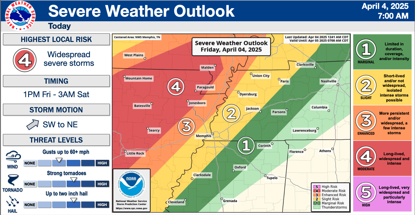
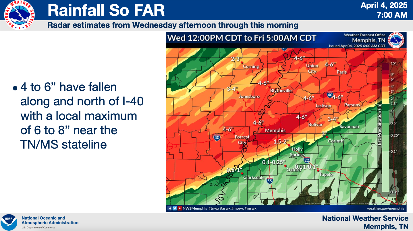
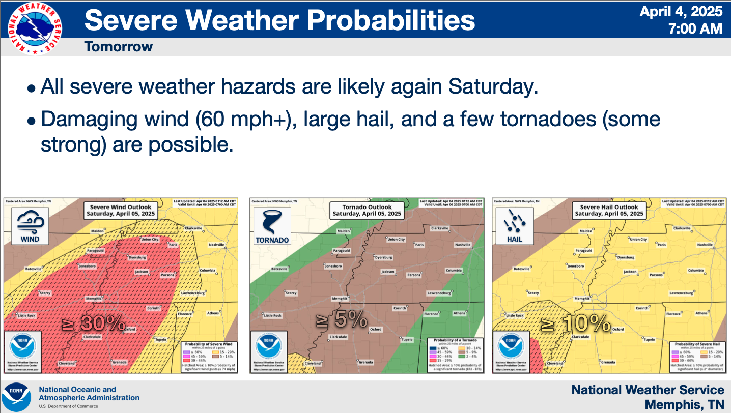
This storm system has already caused five deaths in West Tennessee. It has dumped around 4 to 6 inches of rain on Memphis already.
Credit: National Weather Service Memphis
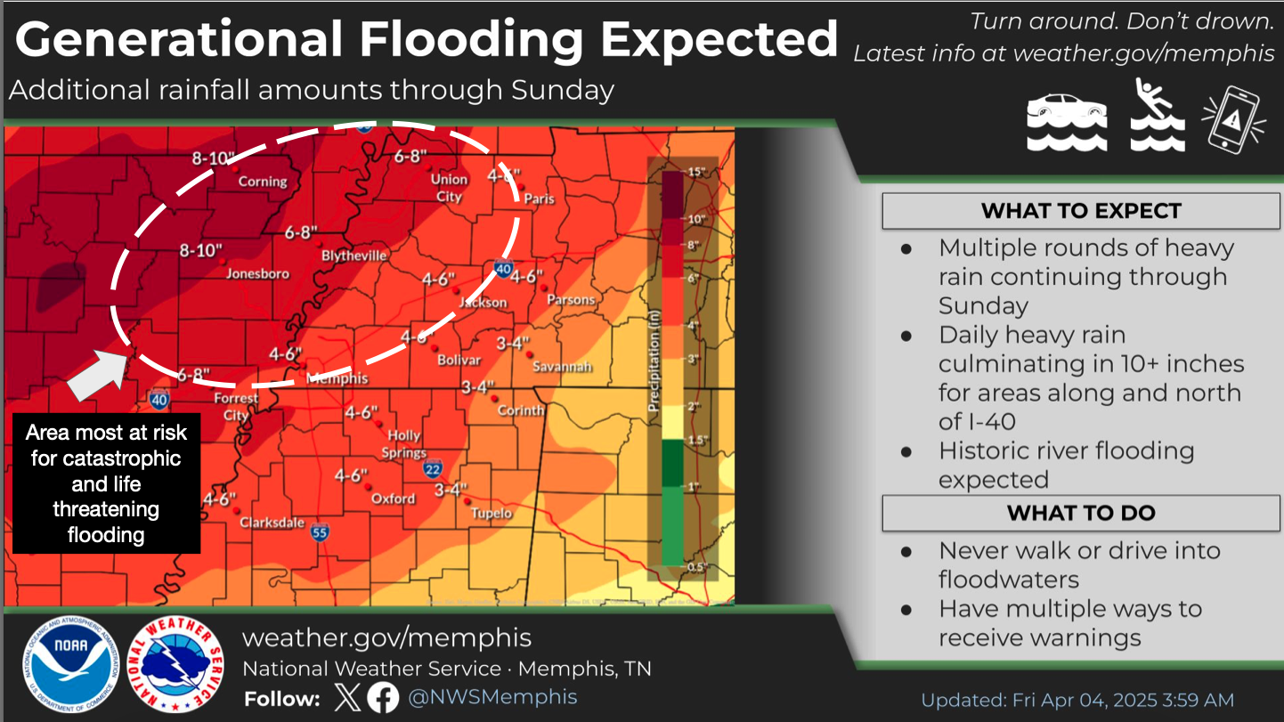
“Generational flooding” is expected in the area as the storm delivers more rain on Friday, Saturday, and Sunday. This could deliver up to 10 inches of rain to areas along and north of I-40 through the weekend. If “generational flooding” was not enough to concern you, the NWS Memphis also predicts the storm could yield “catastrophic flooding.”
Credit: National Weather Service Memphis
However, Memphis fares better in the NWS outlook for Friday than other areas. The agency predicts moderate chances of severe weather, damaging winds, tornados, large hail, and excessive rainfall compared to other areas.
Saturday, though, brings an increased risk for all of those here, especially excessive rainfall.
Credit: National Weather Service Memphis
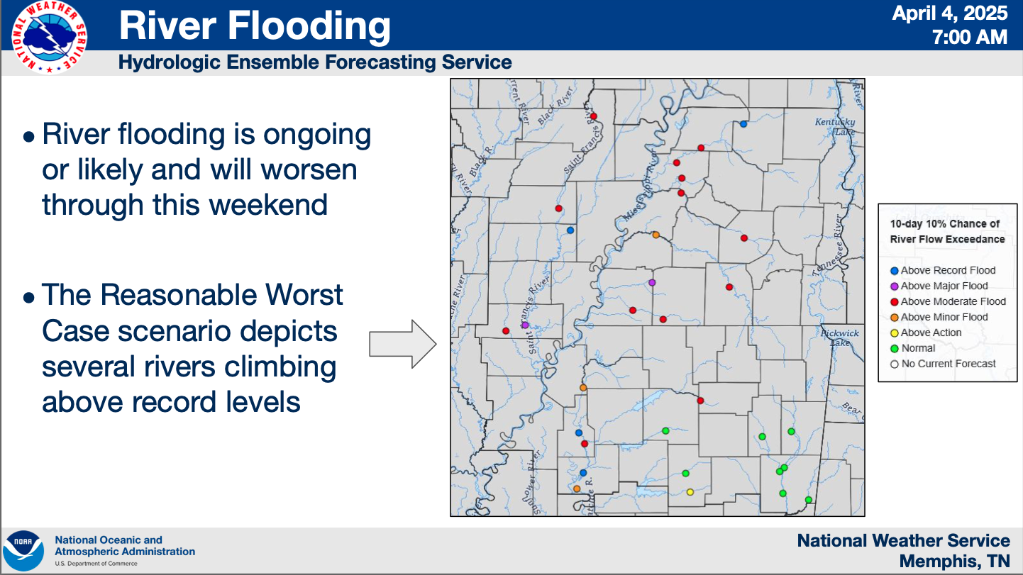
Even when the storm system moves on, its effects will remain in the Shelby County watershed. The briefing predicts an above moderate flood risk for the Wolf River. But it predicts an “above major flood” for the Loosahatchie River, which runs through Frayser and more.
Credit: National Weather Service Memphis
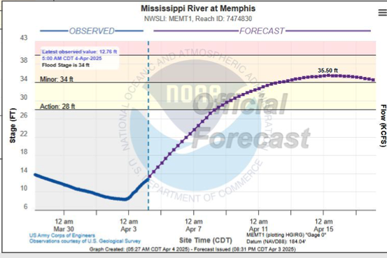
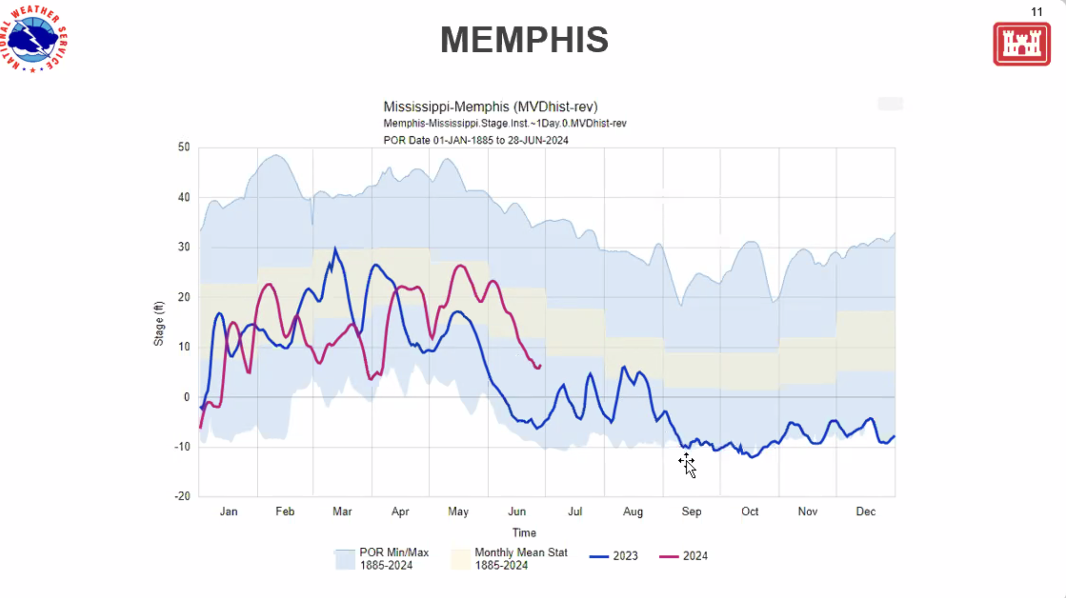
Water levels in the Mississippi River began rising Thursday and are expected to continue until April 15th. River levels had sunk to around five feet early Thursday morning. By Friday morning, levels climbed to nearly 13 feet. The NWS predicts river levels will rise continually, peaking at around 36 feet by mid-April.
Credit: National Weather Service Memphis
Gov. Lee Surveys West Tennessee storm damage
Credit: State of Tennessee
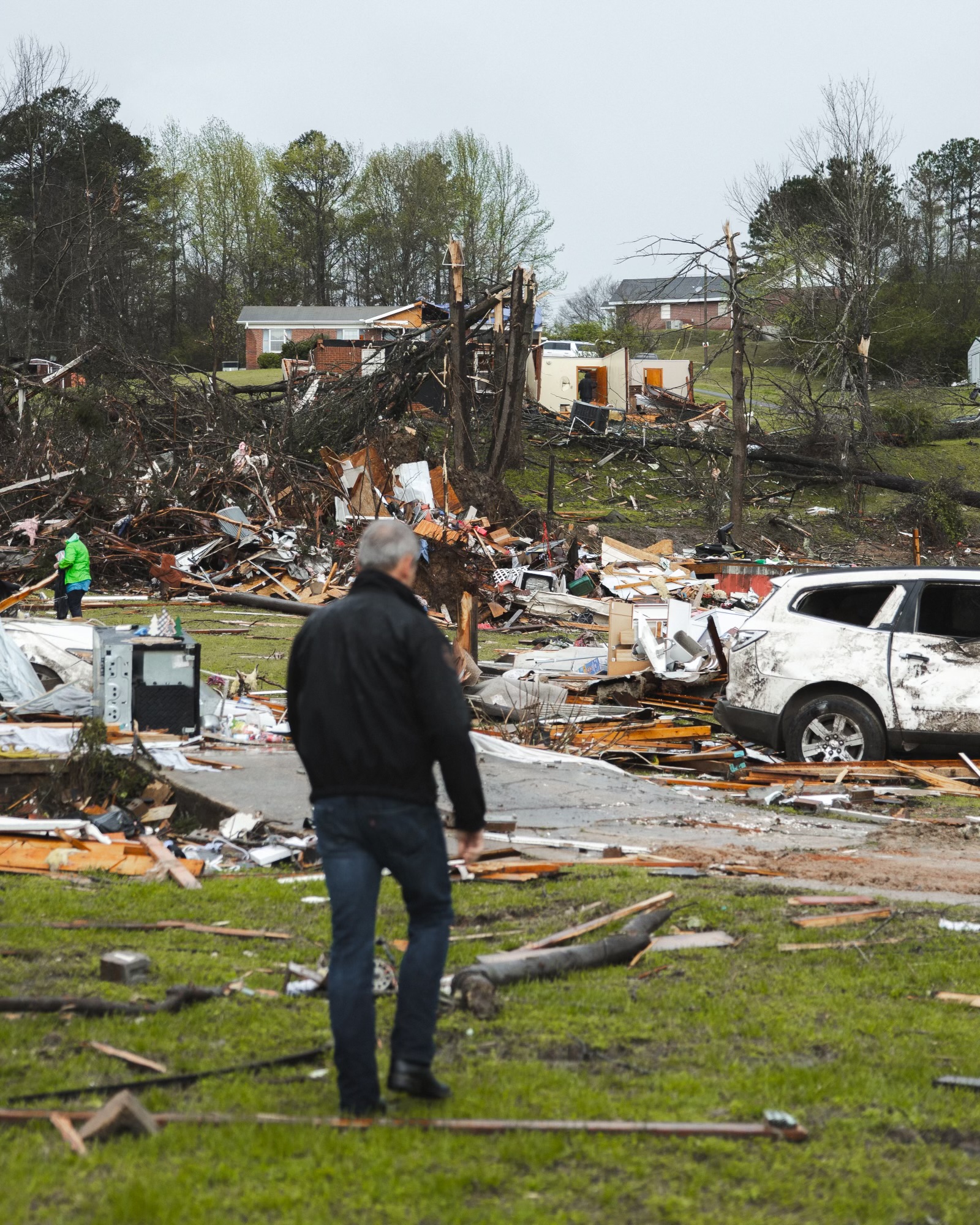
Tennessee Gov. Bill Lee surveyed storm damage in McNairy County Thursday evening after severe storms ripped through part of West and Middle Tennessee.
Lee immediately issued an Emergency Declaration, which was quickly approved by the Trump Adminstration.
Crews in several Tennessee counties continued to survey storm damage Friday and search sites for evidence of tornadoes.
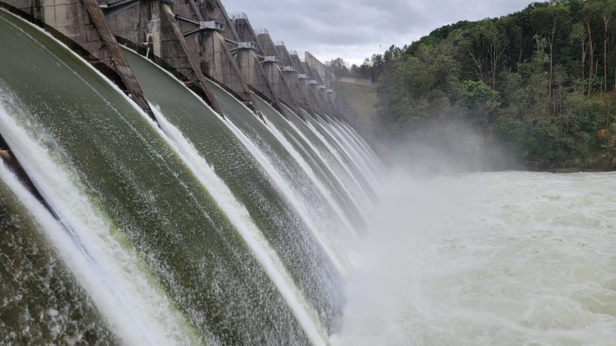
The Tennessee Valley Authority is releasing water from tributary dams like Douglas Dam, shown here, in Sevier County. The controlled release is intended to minimize additional flooding. (Photo: Tennessee Valley Authority)
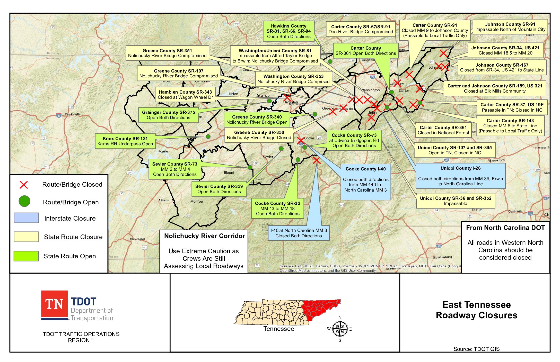
A map from the Tennessee Department of Transportation shows road closures and compromised bridges in East Tennessee.
Four days after Hurricane Helene unleashed devastation across parts of rural East Tennessee, emergency officials are switching from rescue to recovery operations.
Scores of people are still reported missing — a number that has shifted up and down since Saturday — underscoring the immense challenges in accounting for residents in areas with no power, impassable roads, and limited cell service.
As of Monday night, 102 were missing in four counties, according to the Tennessee Emergency Management Agency (TEMA), which stressed that the missing may include those cut off from roads and cell coverage. State officials confirmed at least six Tennessee weather-related deaths thus far, according to TEMA. They include three in Unicoi County, and one person in each of the following counties: Knox, Johnson, and Washington.
Thousands of homes and businesses remain without power, and hundreds of roads and bridges can’t be traveled, including nearly every road linking Tennessee to North Carolina. There is no official toll yet on the number of homes and businesses damaged or destroyed. At least four wastewater treatment plants have been thrown offline due to flooding and water utilities in six counties have reported “operational issues,” according to TEMA.
“Search and damage assessments are ongoing and we’re beginning to be able to start to put the pieces back together,” said Myron Hughes, a public information officer for TEMA’s All-Hazards Incident Management Team.
Hotline to coordinate missing person reports: 800-824-3463
Hughes briefed reporters Monday, alongside public officials in hard-hit Unicoi County, where a dramatic and ultimately successful rescue operation unfolded Friday morning to airlift more than 60 staff and patients stranded on the rooftop of Unicoi County Hospital in Erwin.
Unicoi County Emergency Management Director and Incident Commander Jim Erwin said personnel were conducting searches Monday, a task he expected to be complete in impacted areas by day’s end.
Meanwhile, residents and emergency crews continue to grapple with the damage left behind by high winds, rainfall and flooding in hard-hit counties, including Unicoi, Carter, Cocke, Greene, Hamblen, Hawkins, Johnson, Sevier, and Washington.
At Monday’s Unicoi County press conference, an unidentified man, speaking in Spanish through an interpreter, pressed emergency responders for answers about why his still-missing wife wasn’t rescued as she and co-workers tried to flee rising waters Friday morning outside their workplace, Impact Plastics.
The 911 call system swas inundated and many of the county’s resources were deployed to Unicoi County Hospital, Erwin responded, and noted he was also at the hospital. A crew rescued four people fleeing Industrial Park, where the plastics factory was located, Erwin said, then had to turn back.
“They did not get further because water was already so high,” he said. “Some people were saved and we’re still searching. … We all have hopes that we will find some more alive. Our hearts are deep and we’ll be here to work with families.”
Gov. Bill Lee’s request for a Major Disaster Declaration was approved by the Biden Administration Saturday, activating Federal Emergency Management Agency’s (FEMA) assistance in 12 Tennessee counties.
The Tennessee National Guard and first responders from outside the disaster region were dispatched to assist in search and recovery efforts.
The Tennessee Bureau of Investigation established a hotline number to coordinate reports of missing persons: The number is 800-824-3463.
The Tennessee Valley Authority is releasing water from tributary dams like Douglas Dam, shown here, in Sevier County. The controlled release is intended to minimize additional flooding. (Photo: Tennessee Valley Authority)
Roads and bridges
In the first 36 hours following the disaster, the Tennessee Department of Transportation (TDOT) assessed damages and inspected 100 bridges across seven counties.
“We still have hundreds to go,” a spokesperson said in an emailed statement on Monday.
More than 300 TDOT employees have joined in the inspection efforts, but the task ahead will surpass the capacity of the state agency.
TDOT is in the process of awarding multiple debris removal and construction contracts to supplement state crews, with contracted work expected to begin later this week.
Dams and Rivers
Over the weekend, reports of imminent dam collapses led to evacuations in some areas. But on Monday a spokesperson for the Tennessee Valley Authority confirmed that all 49 of its dams are “stable and operating as designed.”
“We are assessing any transmission infrastructure impacts, which are minimal on the TVA system,” Scott Brooks, an agency spokesperson, said in an email.
Right now, they’re asking for water and people from all over are bringing water to us. Budweiser just brought an entire tractor-trailer full. … Rep. Dan Howell from Cleveland is sending water from his district. When you’ve got 37,000 people and no water, we’re so grateful for everybody doing that.
– Rep. Jeremy Faison, Cocke County Republican
Brooks said most of the damage is on local utility systems. TVA is working with local power companies on restoration and repairs, he said.
State Rep. Jeremy Faison, a Republican who represents hard-hit Cocke County, said thousands are without water after utilities were knocked offline. “So, literally, unless you’re on a well, you have no water in my county right now,” he said.
“Right now, they’re asking for water and people from all over are bringing water to us,” he said. “Budweiser just brought an entire tractor-trailer full. … Rep. Dan Howell from Cleveland is sending water from his district. When you’ve got 37,000 people and no water, we’re so grateful for everybody doing that.”
TVA is monitoring extensive flooding in its tributary dams, which control water movement throughout the power provider’s system. The extensive flooding in reservoirs has prompted record high releases at places, including Douglas Dam in Sevier county.
“We are aware these record releases are causing localized flooding on the Tennessee River,” Brooks said.
River levels monitored by TVA illustrated the enormity of rising water in the region. The French Broad River in Newport, Tenn, reached 23 feet — 13 feet above flood stage. The Pigeon River, also in Newport, set a new record stage of 28.9 feet, 20.9 feet over flood stage. And the Nolichucky River at the Nolichucky Dam in Greene County also recorded record high levels of water.
Senior reporter Sam Stockard contributed to this report.
Tennessee Lookout is part of States Newsroom, a nonprofit news network supported by grants and a coalition of donors as a 501c(3) public charity. Tennessee Lookout maintains editorial independence. Contact Editor Holly McCall for questions: info@tennesseelookout.com. Follow Tennessee Lookout on Facebook and X.
Levee Trail by the Mississippi River (Credit: Big River Park).
A glug of flood water was predicted to elevate Mississippi River levels here over the next two or three days, though officials said that some of the excess water was good news for the region.
Last week, mayors with the Mississippi River Towns and Cities Initiative (MRCTI) explained how seasonal flooding and rains from Hurricane Beryl affected their areas. La Crosse, Wisconsin, for example “pushed right up to major flooding” before waters receded. However, Hastings, Minnesota saw the river crest at more than 19 feet at the beginning of the month, only about five feet below the city’s record, according to the Hastings Journal. But it wasn’t all bad news.
“In some ways, the rain, the precipitation, is welcome,” said La Crosse Mayor Mitch Reynolds. “We just pulled out of a 60-month drought that cost our nation $26 billion. And for the first time since 2022, there is no drought along the Mississippi River corridor.
“June brought record heat and well-below-normal precipitation. July reversed that trend and gave us a recharge and then some. The third thing is this new water has — in some ways — secured our Louisiana cities from additional saltwater intrusion for at least several months.”
Grafton, Illinois, Mayor Michael Morrow. Credit: MRCTI
Grafton, Illinois, Mayor Michael Morrow appeared live at the MRCTI news conference last week with the Mississippi River behind him, encroaching on a city street. At 23.5 feet, the flood level was below the record 31 feet set in 1931, he said. So, “Grafton is open,” Morrow said.
“We like to say that because we don’t have levees, we are right on the river,” Morrow said. “Our tourists, they can some and put their toes in the river. We just had a group of people getting out of a car over here a minute ago. … The little kids came up and touched the river, and off they went.”
The coming high water expected for Memphis began as a wet pattern over Minnesota and Wisconsin in April and May, according to Anna Wolverton, a National Weather Service (NWS) meteorologist who also works for the Army Corps of Engineers Mississippi Valley Division. In June, an “extreme rainfall event” poured over southern Minnesota and South Dakota, she said, and “that’s what officially kicked this flood wave off and it’s still traveling down the Big River and that was three to four weeks ago now.”
As the mayors spoke during a press event, Thursday, the crest was moving though southern Iowa and into central Illinois and northern Missouri. The “really elongated crest“ lasted a few days at each river gauge, Wolverton said.
Predicted Mississippi River levels. Credit: National Weather ServiceCredit: National Weather Service
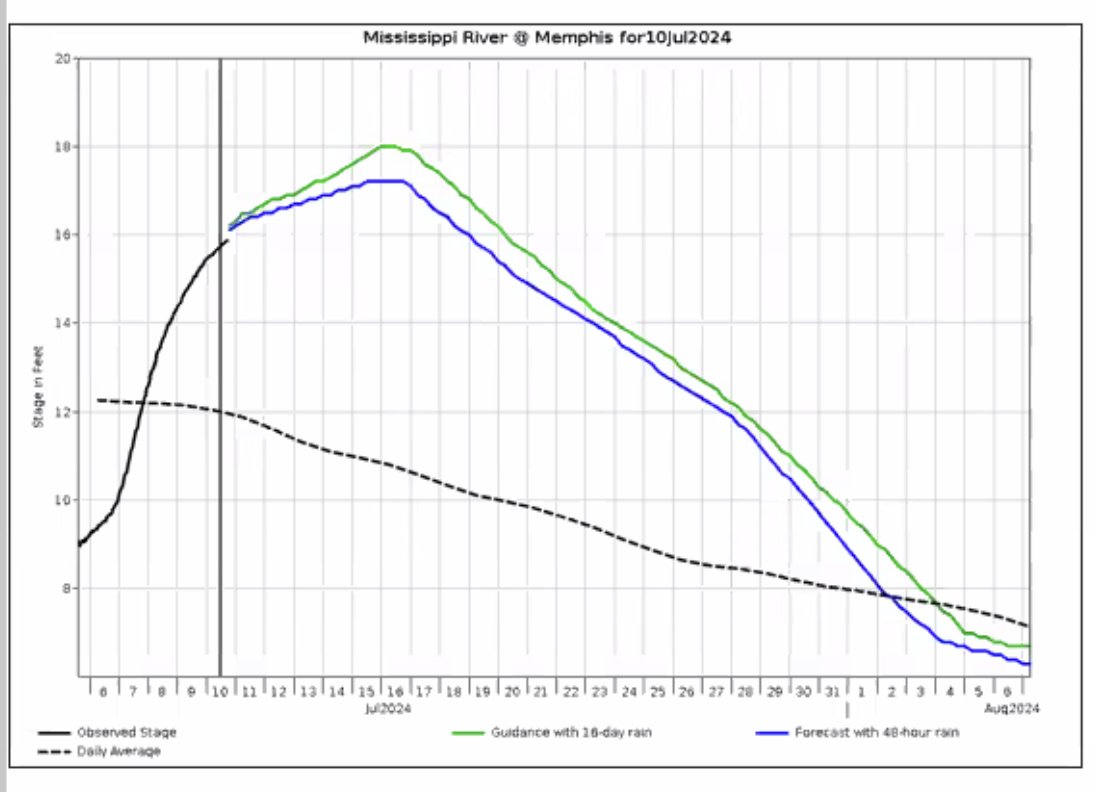
River levels at Memphis began to rise early this month, according to NWS data. On June 6th, the observed river stage was at nine feet. It continued to rise, reaching 16 feet on Thursday. Data from the United States Geological Survey’s (USGS) WaterWatch app said the river stage was at nearly 17 feet (well below the flood stage of 34 feet). The river is expected to crest at 18 feet Tuesday before falling again.
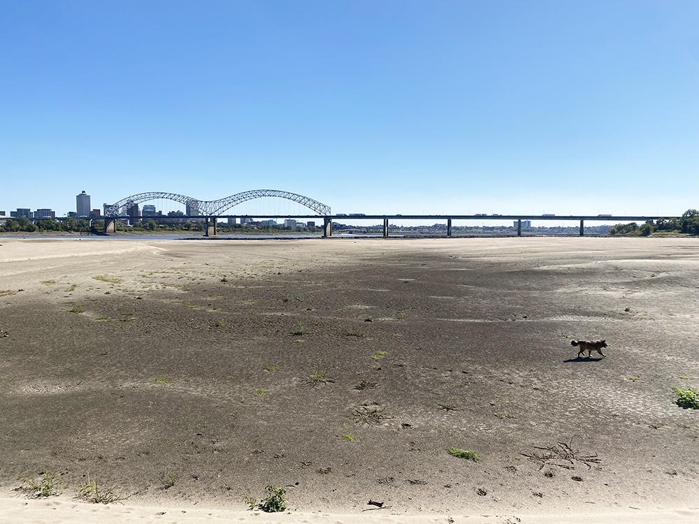
The Mississippi was 10.75 feet below normal in October 2022. (Photo: Bruce VanWyngarden)
Anyone who remembers the bone-dry moonscapes of October 2022’s record-low river levels might wonder what else we can expect this year. Wolverton said it was nearly impossible to predict. But water levels had already begun to fall in early June last year, putting the river at least one month ahead of 2023.
“I expect at least another month or so before we’re talking about low water again,” Wolverton said.
“I expect at least another month or so before we’re talking about low water again.
Anna Wolverton, a National Weather Service (NWS) meteorologist who also works for the Army Corps of Engineers Mississippi Valley Division
But record-warm sea surface temperatures throughout The Atlantic Basin could draw more tropical storms. Federal agencies have already predicted a higher-than-normal hurricane season. Those could bring even more water to the Mississippi River.
So far, the Mississippi River system is prepared for excess water, according to Carl Winters, the USGS National Flood Coordinator. He said two big contributors for Mississippi River flows are waters from the Missouri River and the Ohio River.
While flows on the Missouri River are elevated (at about 90th percentile for historic flows), they are receding. However, flows from the Ohio are low, at about the 30th percentile for known flows. The flow for the Mississippi at Memphis was at 80 percent and rising last week, Winters said.
The I-40 exit for Highway 13 is pretty typical, as these things go. There’s a McDonald’s, three gas stations, a couple of chain restaurants, four motels. Numerous signs tout Loretta Lynn’s Ranch and Resort, just up the road. A little north of Loretta’s place, 15 miles from the exit, sits the town of Waverly, Tennessee, home to 4,000 people and the site of a horrific disaster on the weekend of August 20th.
A freak storm hit the mountains to the east of Waverly that night, dumping 17 inches of rain in six hours near the hill town of McEwen, all-time record for the state. The only outlets for the water were five streams: Trace Creek, Blue Creek, Hurricane Creek, Tumbling Creek, and the Piney River. Waverly has the misfortune to be split by Trace Creek, normally a small clear stream, maybe 30 feet wide, three feet deep in its pools. But on this night, the placid little waterway became a deadly funnel for the torrential rain coming out of the highlands. Dozens of houses along the creek in Waverly, mostly modest frame structures, including some public housing — what locals call the “projects” — were inundated by the wave.
Twenty people were killed. Twin seven-month-old babies were ripped from their father’s arms; two teenage sisters were separated in the deluge. One survived; the body of the 15-year-old, last seen clinging to a piece of debris being washed downstream, was later found. Houses, cars, furniture, appliances, and the contents of more than 100 homes were flushed away.
As you enter Waverly, nothing seems amiss in the business district, which is on higher ground a couple blocks from the creek. But the two streets nearest the stream are a nightmarish wasteland: Houses sit in the middle of streets; cars are stacked against trees like ladders; washing machines, boats, fencing, furniture, books, televisions, and other human detritus are strewn everywhere. At a gas station, a house sits near the pumps, as if looking for fuel. An enormous dead wild boar floats belly-up in a backwater pool.
A freak storm leaves Waverly, Tennessee, in a state of catastrophic despair, with 20 people killed. (Photos: Bruce Vanwyngarden)
I wander the area, taking pictures, trying not to bother the National Guard and other salvage and cleanup operations. A Tennessee park ranger pulls up as I survey the trashed but now-tranquil stream.
“Is this your property?” he asks.
“No, I’m from a Memphis newspaper, up here to do a story.”
“Good,” he says. “All this just disappeared from the news in one day, and it’s just unbelievable what happened here. Go ahead, just be careful.”
I approach a man and woman sitting on the porch of a white frame house that looks largely unaffected by the storm. Across the street, a house sits cockeyed on its foundation with a pickup truck standing nearly vertical in the yard. Tricia and Chris Wilcher, mother and son, have stories to tell.
Tricia was home and saw the water rising, which isn’t uncommon in Waverly. Creeks rise. “We’ve lived through lots of flooding here, but nothing like this one,” she says. “People were out looking at the water. At first it looked like a monster crawling around on the ground between the houses, then BOOM, it was like a tsunami — and everything just got swept away.”
How does a tsunami happen in the middle of Tennessee? The current thinking is that a massive amount of water pooled behind a railroad track bed that suddenly gave way. Chris Wilcher says he witnessed it. “I was on my way home from work in Nashville and I stopped in Gorman because the roads were getting flooded. You could see the water building like a huge lake behind the railroad tracks up there. Then it started pouring over the tracks, then the bed gave way, and all that water just rushed out at once. It looked like a dam had broken, or like the levees with Katrina.”
“Chris saw that and texted me and said, ‘Mom, you have to get out. Lots of water is coming,’” says Tricia. “A friend of his came and got me. Water didn’t get into our house, but it came up to the porch. I’m still having nightmares about it. I’m still shaken.”
She’s not alone. A lot of people are shaken in Waverly. A week after the horror, they stand watching bulldozers clear the streets, everything they owned, gone or destroyed.
On my way out of town, I notice a young woman in shorts and tank-top walking in Trace Creek with a wading stick. She pokes at debris, moves tree limbs, then wades on, looking for something, something that’s likely gone forever.
For information on how you can help, call the Red Cross Disaster Health Services in Waverly: 1-800-REDCROSS.
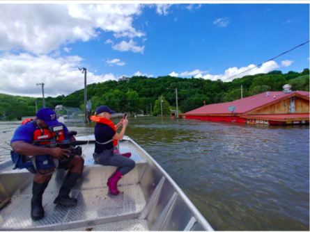
Mayor Rick Eberlin of Grafton, Illinois pilots a boat full of media during a press tour of flooded areas of his city.
This year has been the longest and largest flood season for the entire 31-state Mississippi River Basin, and leaders there want new tools to help them mitigate flood disasters and more.
Mayors in the Mississippi River Valley estimate disaster-related losses in their cities are above $2 billion. The flooding, for example, has damaged homes, temporarily displaced families, and delayed farmers’ planting at record levels, according to the Mississippi River Cities & Towns Initiative (MRCTI).
Check out MRCTI’s full report on flooding here:
[pdf-1]
Cities along the river also need to be prepared for wildfires, earthquakes, storm surge, chemical spills, and more, the group said Wednesday.
Mississippi River Cities & Towns Initiative
Satellite image shows the Mississippi River swelling below Memphis.
The group says it needs access to funds to allow their cities to clean up disasters and help prevent them in the future. A new bill introduced Wednesday could give it to them. The Resilience Revolving Loan Fund (RRF) Act was filed by U.S. Reps. Angie Craig (D-Minnesota) and Rodney Davis (R-Illinois).
“From the drought of 2012 to the excessive heatwave that gripped our area last week, Iowa has seen several multi-century events stack up and worsen over the past few years,” said Mayor Frank Klipsch of Davenport, Iowa. “We need solutions to these impacts that are different than the same old conventional approach — we need real innovation. The RRF provides a new tool to help us prepare.” Mississippi River Cities & Towns Initiative
Clarksville, Missouri uses temporary flood structures to save their downtown as the Mississippi River moves up Main Street.
Red Wing, Minnesota Mayor Sean Dowse called the fund “good fiscal policy.” He said taxpayers get a $6 return for every $1 invested in disaster-resilience programs and mitigation efforts.
Greenville, Mississippi Mayor Errick Simmons said the “Delta has been flood-fighting nonstop for nearly nine months.”
“If we are going to preserve and enhance our economy, we will need to achieve real resilience,” Simmons said. “Some of the most vulnerable communities to climate risk are in the South. Alleviating vulnerability means no longer approaching solutions just inside our backyard, but at regional and corridor scale.”
Mississippi River Cities & Towns Initiative
Satellite image shows the Mississippi River swelling near St. Louis.
The Mississippi River at 38 feet on February 24th.
The Mississippi River is set to crest here at its fourth-highest recorded level next week, but the city said Friday via Twitter that “it shouldn’t be cause for concern.”
The National Weather Service has projected the river, now at 40.5 feet, to crest here at about 41.5 feet on Wednesday, March 6th. This would be the highest the river has been since 2011, when the river reached an historic 48 feet, partially submerging Mud Island and leaving Riverside Drive completely underwater.
National Oceanic and Atmospheric Administration
Forecast of the Mississippi River flood stages
Robert Knecht, director of the city’s Public Works division, said in a video Friday that the water will stay at that level for a few days before it begins to drop. Over the next 30 days, “hopefully we’ll see a significant drop,” Knecht said.
Knecht said the city is “fortunate,” as major flooding should not be an issue. Historically, Memphis has had challenges with flooding, but Knecht said the city has since “invested significantly” to improve the city’s flood control system. The system protects most of Downtown and many residential areas.
“We’re nowhere near what happened several years ago,” Knecht said, citing the 2011 flood. “And it [flood control] worked flawlessly then.”
Knecht said the city will continue to monitor the river, but that right now he doesn’t foresee any challenges.
This week’s sepia-tinged Music Video Monday harkens back to when the levee broke.
“Sharon” is by Memphis singer/songwriter by Tony Manard. “The song is a story from the Mississippi River Flood of 1927,” he says. “I wrote it after going down a Wikipedia rabbit hole triggered by reading about Jeff Buckley drowning in the Mississippi.”
For the video, which he directed, Manard skillfully edited together footage from the 1927 flood and a silent film from the same era.
Manard will be playing at Otherlands this Saturday, July 18 with Stephen Chopek, Harry Koniditsiotis, and Richard James.
Music Video Monday: Tony Manard
If you would like to see your video featured on Music Video Monday, email cmccoy@memphisflyer.com


 Mississippi River Cities & Towns Initiative
 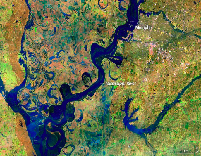 Mississippi River Cities & Towns Initiative
 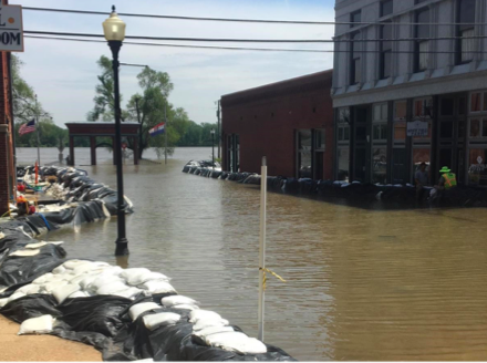 Mississippi River Cities & Towns Initiative
 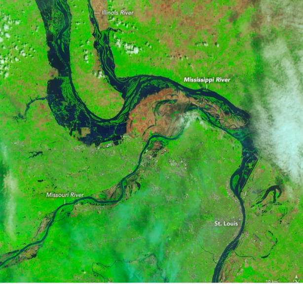 Mississippi River Cities & Towns Initiative
 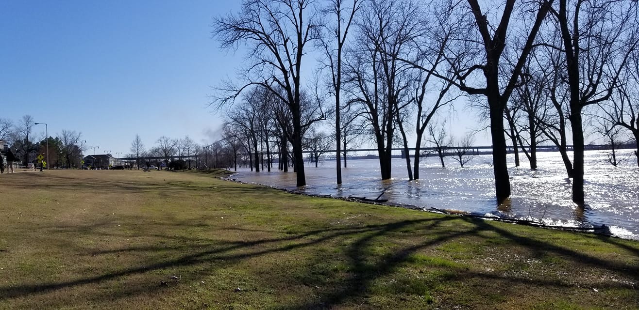 Facebook- Mike Lawhead
 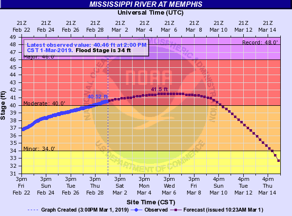 National Oceanic and Atmospheric Administration