I’d been wondering if officials with Memphis in May erred on the side of caution by deciding to move the Barbecue Festival to Tiger Lane in East Memphis. Short answer: They did not.

I’d been wondering if officials with Memphis in May erred on the side of caution by deciding to move the Barbecue Festival to Tiger Lane in East Memphis. Short answer: They did not.
As bad as they are, Mississippi River floods, thankfully, are not what they used to be.
The standard for high water in Memphis is 1937, when the river reached 48.5 feet on the Memphis gauge. That flood, the subject of two books in the last 10 years, made tens of thousands of people in Memphis and Arkansas refugees.
The standard for misery and destruction, however, is the 1927 flood which was lower but broke the levee and flooded a huge part of Mississippi, as described by John Barry in his book Rising Tide and bluesman Charley Patton in “High Water Everywhere.”
Memphian Frances Kauffman, 92, remembers that one. Her mother loaded her and her siblings and the maid into the family Hupmobile and drove to the Harahan Bridge, the only one over the Mississippi River in Memphis at that time.
“It had a wooden viaduct at the end going to Arkansas,” she said. “We drove all the way across, and when we got over, we could not see land ahead as far as we could see. There was no dry land until you got to Forrest City. I can remember it vividly. We were looking out the windows, and that muddy water was all but on the bridge itself. So my mother had to turn around and bring us back. In downtown, the water was over the railroad tracks and all the way up to Front Street and Cotton Row.”
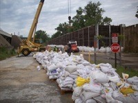
It’s unlikely that anyone will write a famous book or song about the 2011 flood even if it reaches 48 feet or even 50 feet on the gauge next week. A flood is a harsh teacher, the men and women at the U.S. Army Corps of Engineers are fast learners, and levees and flood walls are wonderful things.
On Tuesday, workers were stacking sandbags at the base of the flood wall behind the Pyramid, which is apparently out of harm’s way. (Too bad, some of you are thinking.) The parking lots on Mud Island Greenbelt Park were closed, but most of the sidewalk was open. The residential and commercial part of Mud Island was high and dry.
Architect Tony Bologna, part of the team that developed Harbor Town, is confident it will stay that way. Mud Island was reshaped and built up 10 to 12 feet when the Hernando DeSoto Bridge was built.
“At Harbor Town, we are six to 10 feet above the 100-year flood,” he said. “At 45 feet on the gauge, we are fine. At 48 feet, we would be concerned about the 12 cottages on the harbor. That is the only place we have any potential problem.”
This is the new 100-year flood. The National Weather Service defines that as an event that statistically has a 1 percent chance of occurring in any given year.
Extreme weather has been clobbering mathematics lately. It’s only been 74 years since the Great Flood of 1937. And one year ago this week, Nashville was swamped by a 500-year flood. This is one civic competition that I hope we lose.