Categories
News Blog News Feature

2021 Gulf “Dead Zone” Predicted to be Size of Connecticut

Scientists have collected data on this annual dead zone in the Gulf of Mexico since 1985. But for the last four years, scientists with the National Oceanic and Atmospheric Adminstration (NOAA) have focused on the Gulf’s dead zone where oxygen levels are low and predicted its size. 

This year’s zone is smaller than the five-year average of 5,400 square miles and nearly half of the 2017 record zone of 8,776 square miles. But at 4,880 square miles, the zone is not small — it’s comparable to the state of Connecticut’s 4,849 square miles.

The dead zone is primarily caused by excess nutrient pollution from human activities in urban and agricultural areas throughout the Mississippi River watershed. When the excess nutrients reach the Gulf, they stimulate an overgrowth of algae, which eventually die and decompose. This depletes oxygen in the water as they sink to the bottom. 

The resulting low oxygen levels near the bottom of the Gulf cannot support most marine life. Fish, shrimp, and crabs often swim out of the area, but animals that are unable to swim or move away are stressed or killed by the low oxygen. This dead zone flows west from the tip of Louisiana and hugs the coast. 

Most of the pollution that creates the dead zone arrives there by the Mississippi River watershed, which encompasses 40 percent of the continental U.S. And cross 22 state boundaries. That’s how Tennessee contributes to the dead zone, sending mainly agricultural runoff (like fertilizer) and treated human waste down the river. All along Tennessee’s river coast — including Memphis — treated human waste is the biggest source of pollution followed by fertilizer, according to data from the United States Geological Survey.  

(Credit: USGS) Mississippi River at Vicksburg, Mississippi

Memphis now operates under a 2012 federal consent decree after a number of agencies alleged the city illegally allowed its sewer system to overflow into the river. In 2016, the city’s system spilled millions of gallons of untreated wastewater into the Mississippi. The city is now working toward the end of the 10-year Sewer Assessment and Rehabilitation Program (SARP10) program to update the sewer system. 

“Like many other cities, Memphis has an aging wastewater collection and transmission system that consists of buried pipes, manholes, and pumping stations,” Memphis Mayor Jim Strickland says on the SARP10 website. “In fact, parts of our system are more than a century old. Due to age, our sewers have experienced some deterioration.”

The federal Mississippi River/Gulf of Mexico Hypoxia Task Force is also working to reduce the size of the dead zone to a five-year average size of 1,900 square miles.  

“Through state leadership in implementing nutrient reduction strategies, support from [Environmental Protection Agency – EPA] and other federal agencies, and partnerships with basin organizations and research partners, we will continue to tackle the challenge of Gulf hypoxia,” said John Goodin, director of the EPA’s Office of Wetlands, Oceans and Watersheds.

Categories
News The Fly-By

Dead Water

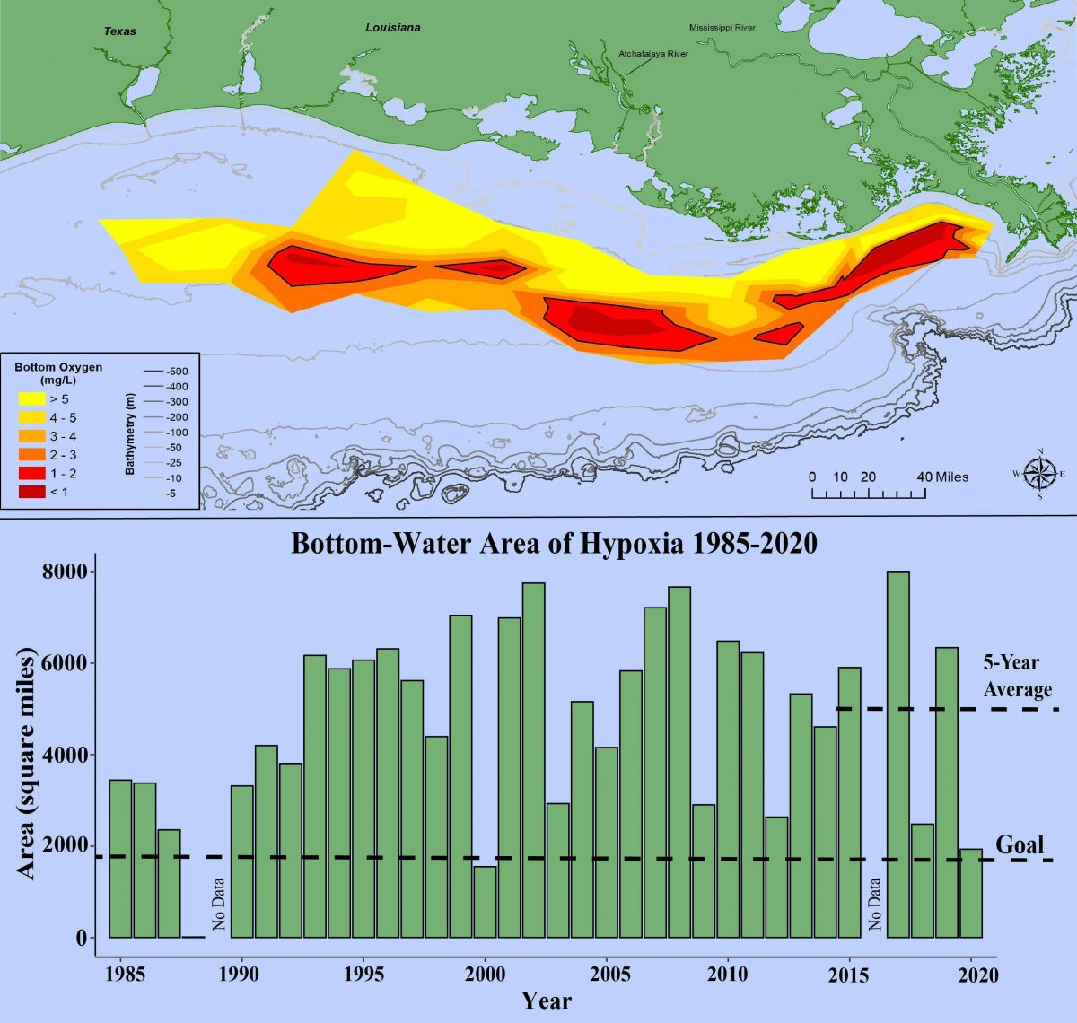
Follow that big, muddy Mississippi River all the way to the Gulf of Mexico, and you’ll find a dead zone the size of New Jersey.

Nutrients found in everything humans dump in the river — sewage, agricultural runoff, industrial waste, and more — stimulate the growth of algae, which sucks up much of the oxygen out of the water, killing fish and marine life in “one of the nation’s largest and most productive fisheries,” according to the United State Geological Survey (USGS).

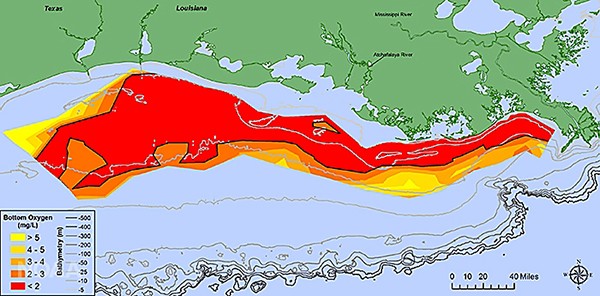
That dead zone this year was 8,776 square miles, according to the National Oceanic and Atmospheric Administration (NOAA). The toxic plume stretches from the tip of Louisiana’s boot to the Texas coast, and in it, you can find Tennessee.

The state ranks seventh nationally in the amount of nitrogen and phosphorus, the nutrients that mainly contribute to the dead zone, it puts into the Mississippi River, according to figures from the USGS. The state is responsible for 5.5 percent of nitrogen in the river each year and 5.3 percent of the river’s phosphorus. Illinois leads this list, contributing a total of about 29 percent of those dead zone nutrients.

Most of the nutrients come from farms, especially from corn and soybean production, according to the USGS. Farmers spray fertilizers and other chemicals on their crops, and rain waters carry them into streams, which eventually drain into the Mississippi.

Nitrogen levels in the river were near the highest levels since scientists began measuring it in the river in 1997. Couple that with heavy rains in the Midwest earlier this year, and you get the record-breaking dead zone, according to NOAA.

Efforts are ongoing to reduce the pollution and shrink the dead zone. A federal task force formed an action plan in 2008 and has reported its work to Congress every year since then. Also, back in 1997, the federal government asked farmers in the Mississippi watershed to voluntarily reduce their pollution levels.

“The latest Mississippi River water quality measurements demonstrate that spending $46 billion since 1997 to encourage farmers to reduce farm pollution voluntarily simply has not worked,” according to Emily Cassidy, writing for the nonprofit Environmental Working Group.

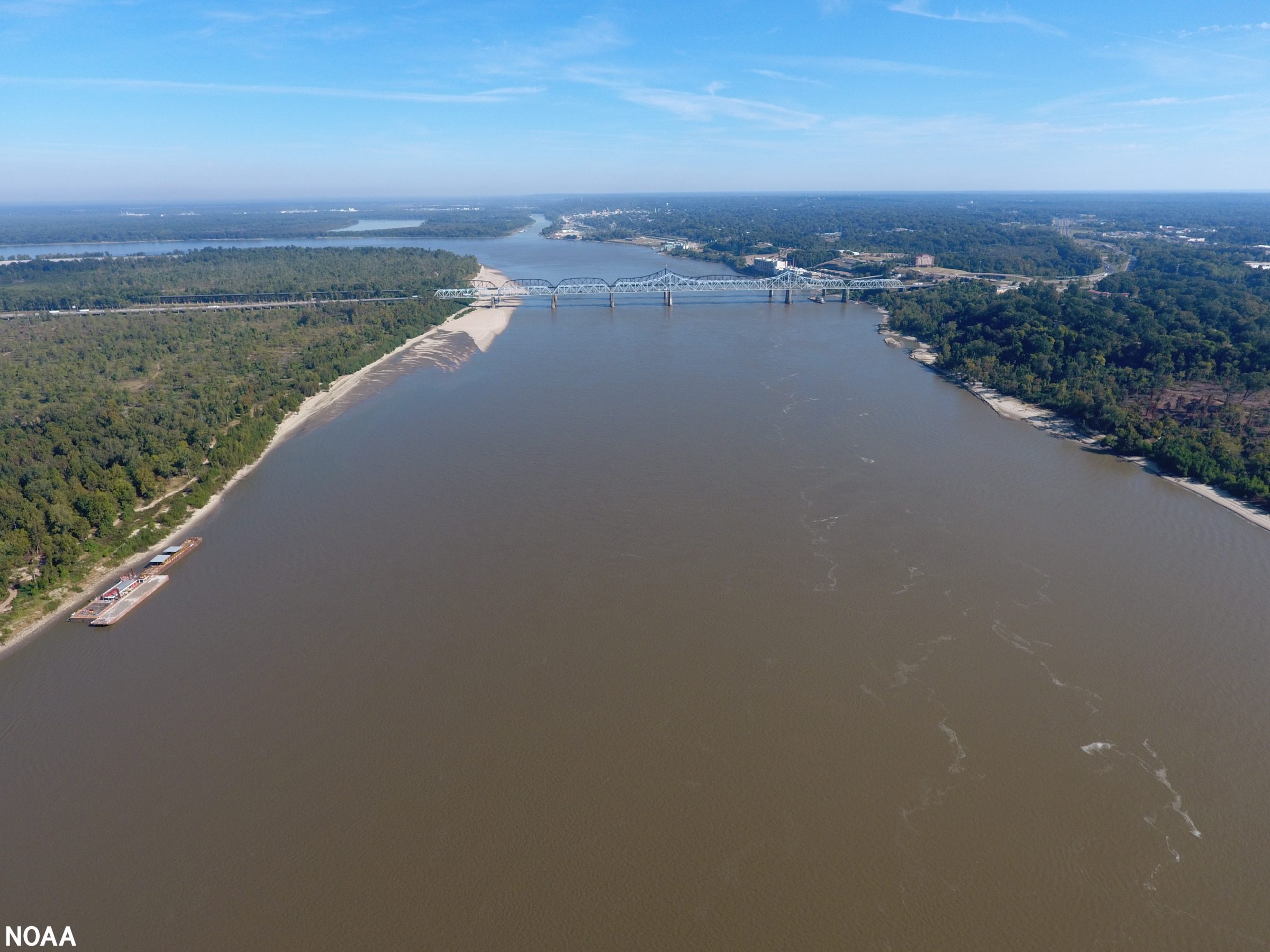
The river is a funnel that drains about 1.2 million miles of all or parts of 31 states and two Canadian provinces. Renée Hoyos, executive director of the Tennessee Clean Water Network, said the river drains about one-third of the nation, and the nation uses it as a “sewer.”

“By the time it gets to Memphis, it’s in pretty bad shape because it’s at the bottom of different sources of pollution that’s come to us from as far away as Montana,” Hoyos said.

Memphis has oft-times made that Mississippi River water worse. The city now operates under a 2012 federal consent decree after a number of agencies alleged the city illegally allowed its sewer system to overflow into the river. In 2016, the city’s system spilled millions of gallons of untreated wastewater into the river. (See our cover story for more.)

Tennessee is not alone, though. In a 2016 study, the Mississippi River Collaborative found that no state has effectively reduced its nitrogen and phosphorus pollution. And it may not end soon.

“I honestly can’t see the [Environmental Protection Agency] under the Trump administration taking the steps necessary, such as setting enforceable limits on dead-zone-causing pollution, to reverse this alarming trend,” said Matt Rota, senior policy director for the Gulf Restoration Network.

Categories
News

EPA Should Coordinate State Efforts to Protect the Mississippi River

AP – States and the federal government need to coordinate their efforts to monitor and protect the water of the Mississippi River, a new analysis urges.

The study released Tuesday by the National Research Council calls on the Environmental Protection Agency to coordinate the efforts affecting the river and the northern Gulf of Mexico where its water is discharged.

“The limited attention being given to monitoring and managing the Mississippi’s water quality does not match the river’s significant economic, ecological and cultural importance,” said David A. Dzombak, professor of environmental engineering at Carnegie Mellon University in Pittsburgh.

Dzombak, who was chairman of the committee that prepared the report, said that “in addressing water-quality problems in the river, EPA and the states should draw upon the useful experience in the Chesapeake Bay watershed, where for decades the agency has been working together with states surrounding the bay to reduce nutrient pollution and improve water quality.”

Because it passes through or borders many states, the river’s quality is not consistently monitored, the report said.

In the north, the Upper Mississippi River Basin Association has promoted many cooperative water-quality studies and other initiatives, the report said. That group includes Illinois, Iowa, Minnesota, Missouri and Wisconsin.

But there is no similar organization for the lower-river states — Kentucky, Tennessee, Arkansas, Mississippi and Louisiana — and they should strive to create one, the report said.

EPA also should support better coordination among states, and among its four regional offices along the river corridor, the report says.

Greater effort is needed to ensure that the river is monitored and evaluated as a single system, said the report.

While the 10 states along the river conduct their own programs to monitor water quality, state resources vary widely and there is no single program that oversees the entire river.

In recent years, actions have reduced much point-source pollution, such as direct discharges from factories and wastewater treatment plants.

But the report notes that many of the river’s remaining pollution problems stem from nonpoint sources, such as nutrients and sediments that enter the river and its tributaries through runoff.

Nutrients from fertilizers create water-quality problems in the river itself and contribute to an oxygen-deficient “dead zone” in the northern Gulf of Mexico.

The National Research Council is an arm of the National Academy of Sciences, an independent organization chartered by Congress to advise the government on scientific matters. — Randolph E. Schmid