As the city slowly puts itself back together, the question hovering at the back of many people’s minds is “What the hell just happened?”
Dr. Dorian J. Burnette, Assistant Professor of Earth Sciences at the University of Memphis, studies severe weather of all kinds. (As you might recall from my April cover story, he is also a climatologist.) He says the storm was not a tornado or ordinary thunder boomer. It was a derecho, a term that comes from the Spanish for “straight ahead”.

“Derechos occur when a line of thunderstorms produce widespread wind damage along a path of 250 miles or more. There has been a proposal in the weather community from Stephen Corfidi and others at the Storm Prediction Center in Norman, Oklahoma, to revise the definition of a derecho to include a damage swath of 60 miles in width occurring along a path of 400 miles or more, but that is not official yet. However, even by that revised definition, the windstorm back on the 27th would still be classified as a derecho,” he says.
Burnette says meteorologists concerned with the potential of severe weather were monitoring the Mid South all day on May 27. “Though there were uncertainties in how the storms would evolve during the day, we knew the environment was prime for a derecho. Derecho environments have an extreme amount of instability due, in part, to a large amount of low-level moisture. We also look for decent winds and drier air between 10,000 and 18,000 ft aloft. These conditions not only allow thunderstorms to develop and organize, but the drier air aloft helps intensify thunderstorm downdrafts aiding in the development of high straight-line winds. Finally, we look for a front oriented in such a way that storms can use it as a “train track,” move east or southeast, and continuously feed on the warm air moving into the region in the low- to mid-levels of the atmosphere. All of these conditions need to extend from where storms are expected to develop downstream 250 miles.”
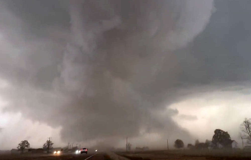
All of these conditions were present on May 27, leading to what Burnette called “strongly worded” statements from the Storm Prediction Center in Norman, Oklahoma. That night, line of thunderstorms merged together in a pattern meteorologists call a “bow echo”, after its distinctive radar signature. The storm system bore down on the city from the northeast, bringing sustained winds of 65-80 mph. “These wind speeds would make this event weaker than the derecho, known by Memphians, as Hurricane Elvis in 2003. By power loss numbers from Memphis Light Gas and Water, the event on Saturday would rank 3rd behind Hurricane Elvis in 2003 and an ice storm in 1994.”
Sustained winds of 80 mph are no laughing mater, but there is evidence of another phenomenon at work. The damage was not uniform across the Mid South, with some areas devastated and others escaping relatively unscathed. Some of this discrepency could be attributed to chaotic wind patterns caused by the urban environment, but Burnette says the severe damage around the Memphis Police Academy area in Frayser, in which downed trees and power lines were scattered in a radial pattern, is “strong evidence” of a phenomenon known as a microburst, which can cause localized extreme damage. “A downburst is a strong downdraft produced by a thunderstorm that causes damaging winds at the surface. Estimates based on the tree damage suggest these winds were around 95-105 mph. However, this level of damage was confined to a small area (less than 2.5 miles). Thus, the downburst is termed a microburst. In other words, the term microburst is describing the size of the downburst. If the damage was 2.5 miles or more it would have been termed a macroburst. Certainly, other microbursts could be one possible explanation for the different levels of damage around the city.”