Someone created a meme that went viral last Friday, as Hurricane Helene was proceeding to devastate portions of six states. It was a photo of Florida Governor Ron DeSantis on a cell phone standing near some trailers and overturned chairs. The caption read: “Hello, President Biden, it’s Ron! May I please have some socialism?”
The meme was being enacted in real life as Helene churned relentlessly across the Gulf of Mexico toward the southeastern U.S. The governors of five of the soon-to-be affected states (Alabama, Florida, Georgia, North Carolina, and South Carolina) had declared a state of emergency two or three days in advance of the storm, asked for federal help, and quickly got it approved by President Biden.
The sixth state? That would be Tennessee, where our cosplaying Christian governor, Bill Lee, decided to take a bold alternative course of action. None of that damn socialism for Bill, nosiree. Last Friday morning — the day the Category 4 hurricane made landfall — Lee asked Tennesseans to participate in a “day of prayer and fasting.” Give me a G—damn break. What criminal incompetence!
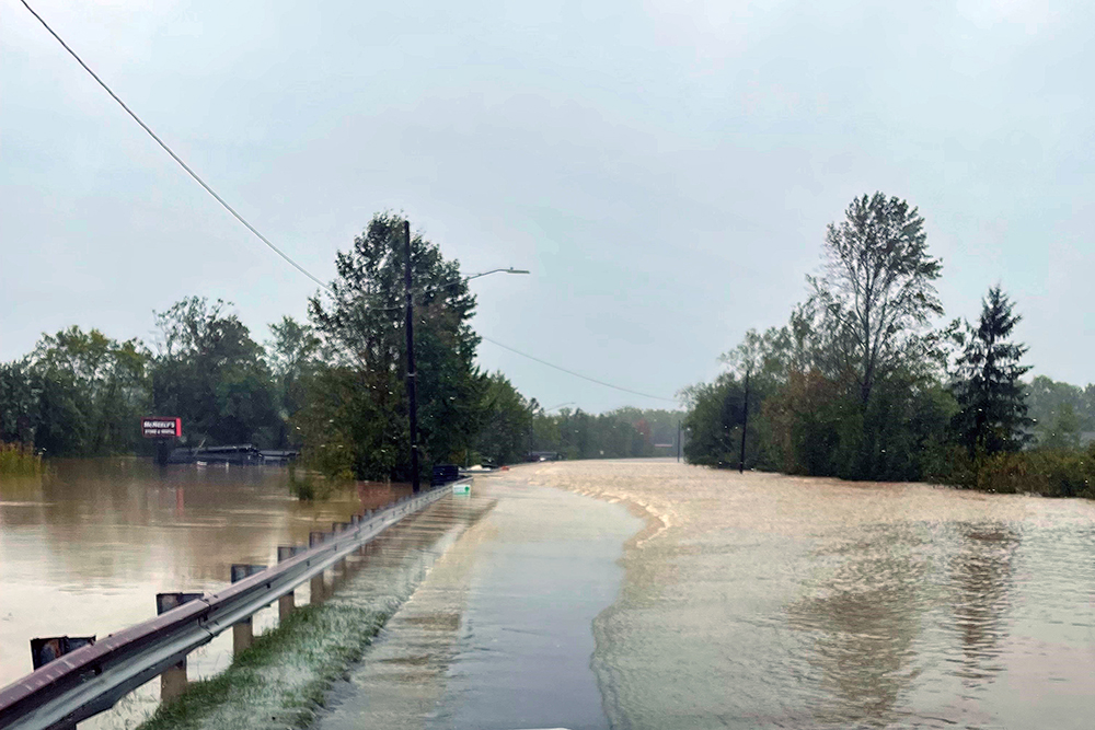
Friday afternoon, after flood waters in eastern Tennessee had destroyed several towns, threatened dams, and put tens of thousands of people out of their homes, 54 patients and staff huddled atop a hospital in rural Unicoi County, Tennessee, awaiting help. Fortunately for them, Virginia and North Carolina rescue workers were able to provide lifeboats and helicopters and get them to safety. Good ol’ Rocky Top? Not so much. Governor Lee finally got around to declaring a state of emergency Friday night. Guess he was hungry from fasting all day?
On Saturday, Lee and GOP Senator Marsha Blackburn surveyed the damage and destruction from an airplane. (Blackburn had spent the day of the hurricane in Michigan, “interviewing” Donald Trump at a rally.) We can only presume she was also fasting and praying after voting to shut down the government earlier in the week.
As the remnants of Helene began to dissipate, millions of Americans were left without power, water, and phone service across the Southeast. Roads, homes, businesses, bridges, and other pieces of the infrastructure were flushed downstream. As I write this, the storm has been blamed for at least 120 deaths across five states, with that total expected to rise as waters recede.
Asheville, North Carolina, which was absolutely destroyed, is 500 miles from the Florida coastline where Helene made landfall and sits at an elevation of 2,134 feet. For reference, Memphis is 325 miles from the gulf and sits at an elevation of 338 feet.
Climate change is here, and all the fasting and prayers in the world aren’t going to fix it. We need credible research and forecasting, and science-based information about what we’re dealing with.
The National Oceanic and Atmospheric Administration (NOAA), which oversees the National Weather Service, FEMA, Office of Ocean and Atmospheric Research (OAR), and other climatological agencies, is responsible for keeping state and local officials and the public aware of severe weather and other climate-based threats. Without the updates and forecasts from NOAA, Americans would be, well, up a creek.
That much would seem obvious … unless you’re a devotee of Project 2025, the GOP’s 920-page policy blueprint for the next administration. Candidate Trump has disavowed it, but it was written by several former Trump administration officials. Project 2025 devotes a whole four pages to NOAA and the National Weather Service. The section was written by Thomas F. Gilman, an official in Trump’s Commerce Department. The document calls the NOAA a “primary component of the climate-change alarm industry” and says it “should be broken up and downsized.” Project 2025 also says the National Weather Service “should focus on its data-gathering services” and “should fully commercialize its forecasting operations.”
Yeah, that damn climate-change alarm industry is just more socialism! Wake up and smell the ozone, sheeple! There’s money to be made on the weather! Fox News or X or Newsmax will take over hurricane forecasts and monetize ’em. It will be like fasting and praying about weather emergencies, only with opinions and ads. What could go wrong?


 National Weather Service