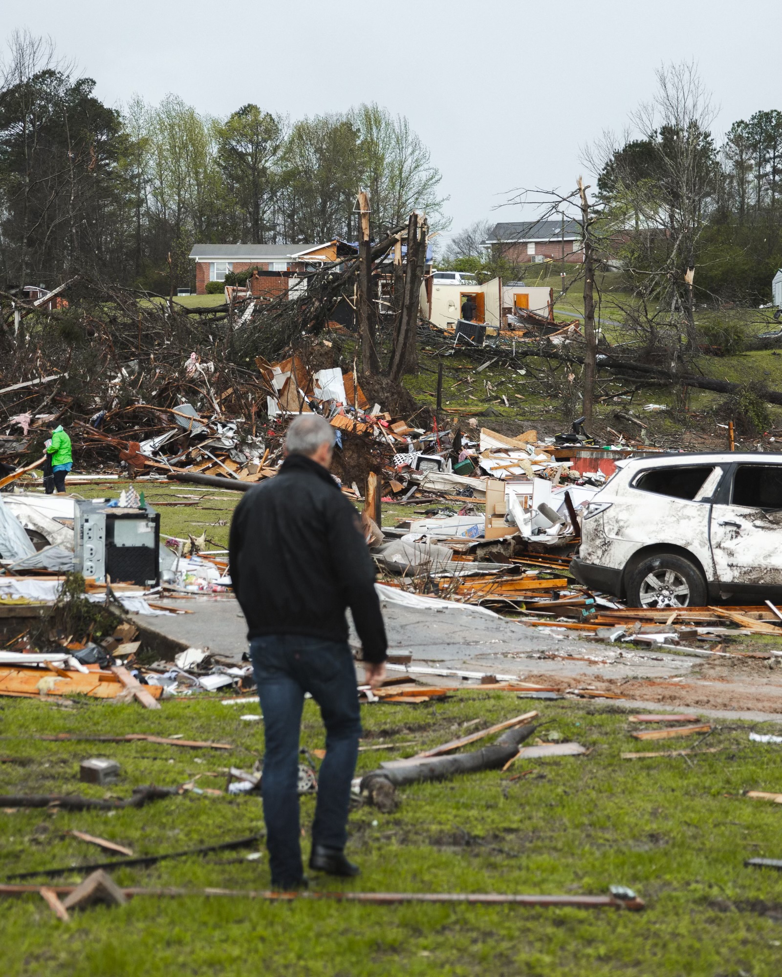
A chain of severe storms and a possible tornado killed at least five people across West Tennessee early Thursday.
The storms left a path of major damage in Fayette, Hardeman and McNairy counties, according to the Tennessee Emergency Management Agency (TEMA). An EF-3 tornado struck the town of Selmer, Tennessee, according to preliminary surveys from crews deployed by the National Weather Service Memphis.
Residents of West and Middle Tennessee received multiple severe storm, tornado and flood warnings throughout Wednesday night into the early morning hours Thursday.
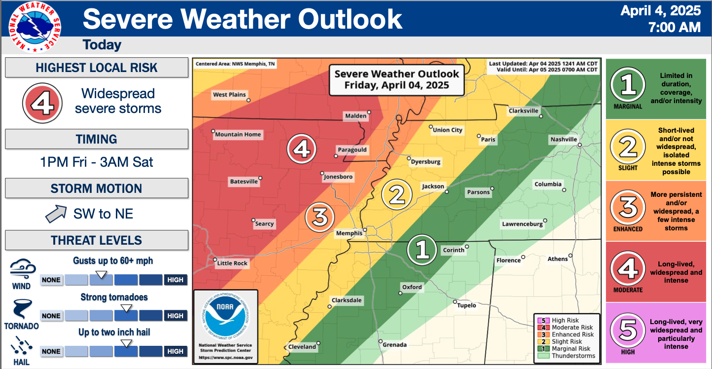
The National Weather Service issued more than 70 severe thunderstorm warnings, more than 50 tornado warnings and 21 flash flood warnings in the last 24 hours, TEMA reported Thursday afternoon.
NWS received reports of observed tornadoes and damage for seven of those tornado-warned storms.
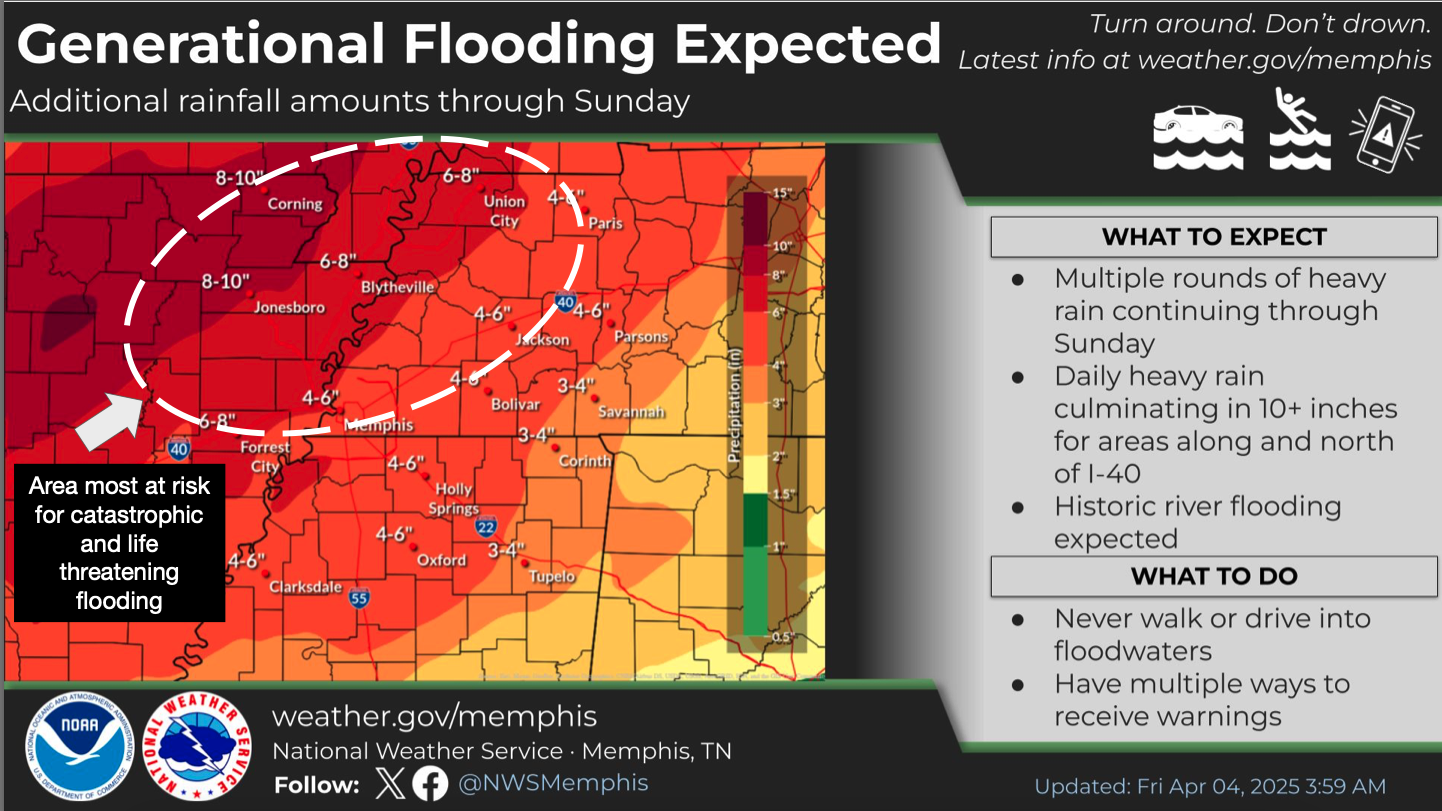
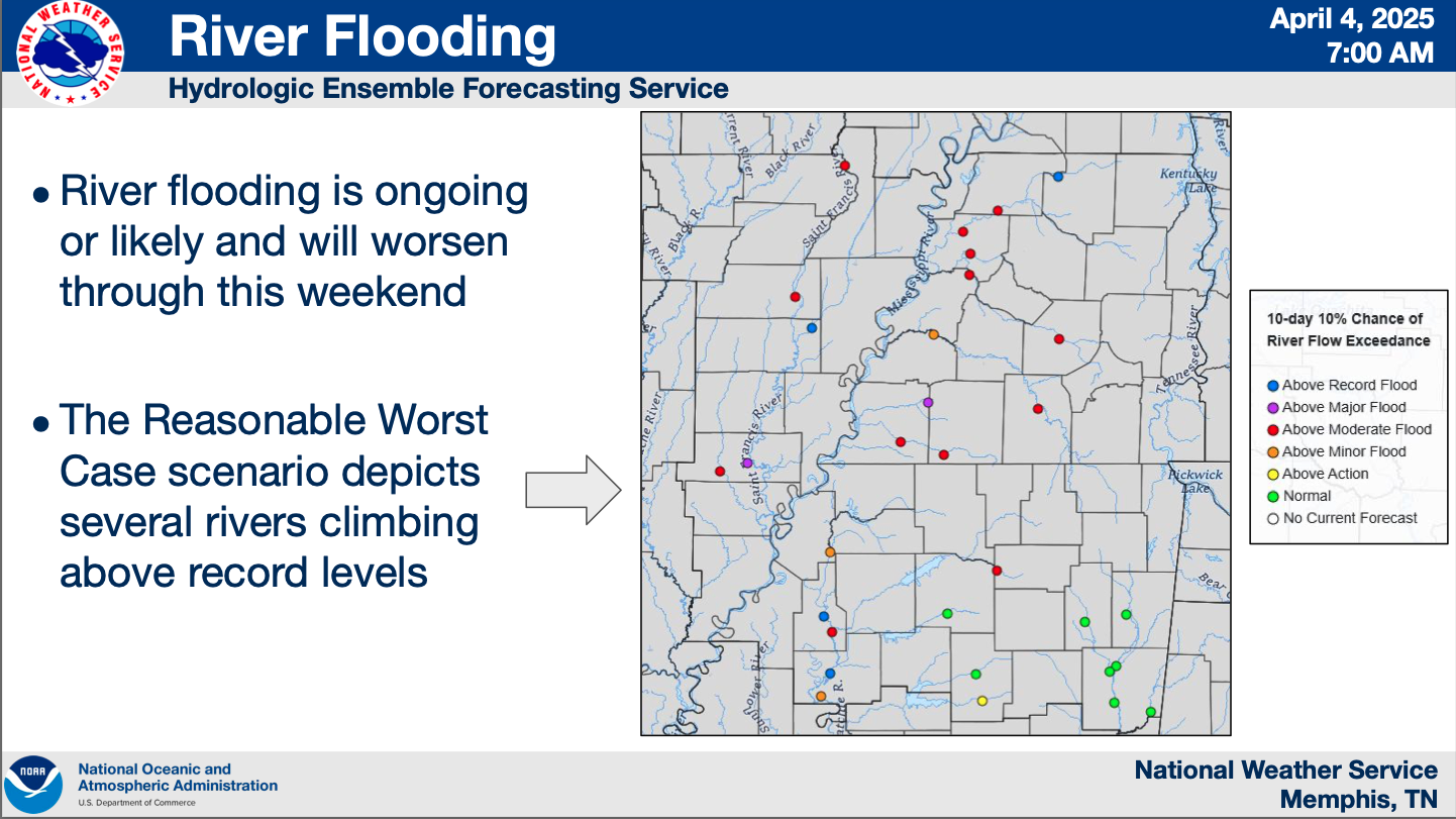
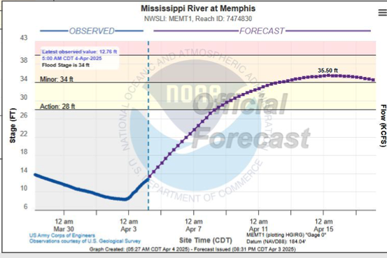
State officials warn that “generational flooding” — flooding so severe it happens once a generation or once a lifetime — continues to pose a threat to multiple counties in Middle and West Tennessee as multiple rounds of heavy rain are forecast to stretch into Sunday.
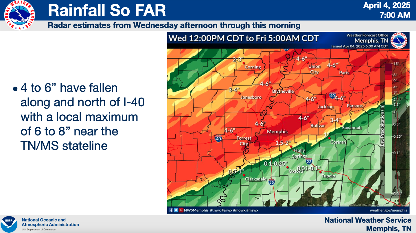
Rain totals could reach at least 10 inches in areas of West Tennessee north of Interstate 40 by the end of the weekend, according to National Weather Service Memphis. The northwest corner of the state could see up to 15 total inches of rain.
Gov. Bill Lee requested an Emergency Declaration for Tennessee and TEMA Director Patrick Sheehan issued a State of Emergency Wednesday evening in anticipation of the severe storms and flooding.
Lee’s request includes federal assistance for debris removal, emergency protective measures and direct federal assistance.
President Donald Trump approved Lee’s request around 11 a.m. Thursday, making FEMA assistance available to all 95 Tennessee counties. Under the declaration, FEMA can provide equipment and resources to support emergency response, and direct federal assistance under the public assistance program will be provided at 75 percent federal funding, according to the agency.
The state remains under a level 3 State of Emergency status, which allows state resources to support local requests for assistance following severe weather while continuing to provide support for ongoing Tropical Storm Helene recovery efforts in East Tennessee.
Five deaths, multiple injuries reported
At least five people have been reported dead, state and local officials confirmed.
The Tennessee Department of Health confirmed one death each in McNairy County, Obion County and Carroll County.
A 48-year-old man was pronounced dead in Fayette County around 2 a.m. Thursday after the Fayette County Sheriff’s Office responded to a call reporting a tornado had overturned a modular home, according to the Fayette County Emergency Management Agency.
Four other family members were transported to a nearby hospital, two in critical condition and two in stable condition. The man’s 16-year-old daughter later died at the hospital, the Fayette County Sheriff’s Office confirmed.
Tornado damage assessments begin
NWS Memphis does not yet have an exact number of confirmed tornadoes from Thursday morning’s severe weather event.
Teams are assessing tornado damage in Selmer, Tennessee and Lake City, Arkansas to confirm and classify the strength of tornadoes, according to NWS Memphis.
Selmer saw an EF-3 tornado with peak winds estimated at 160 miles per hour, according to preliminary survey results released by NWS Memphis Thursday afternoon. The agency suspended further surveys of the area out of concern for surveyors’ safety in ongoing storms.
In Arkansas, the preliminary survey shows Lake City also saw an EF-3 tornado with top winds around 150 miles per hour.
Ratings could change after surveys are complete, NWS Memphis stated.
The agency received additional reports of tornados in the region from spotters and radar but crews have not yet been able to survey damage or confirm.
Tennessee Highway Patrol deployed a strike team to McNairy County to support local officials, according to TEMA.
“My heart breaks for our city and county at this time,” Selmer Mayor Sherry Inman stated in a social media post expressing gratitude for those who have offered assistance or prayers. “Please continue to pray for all the families and homes that have been lost.”
State officials report power outages, roads blocked by water or debris
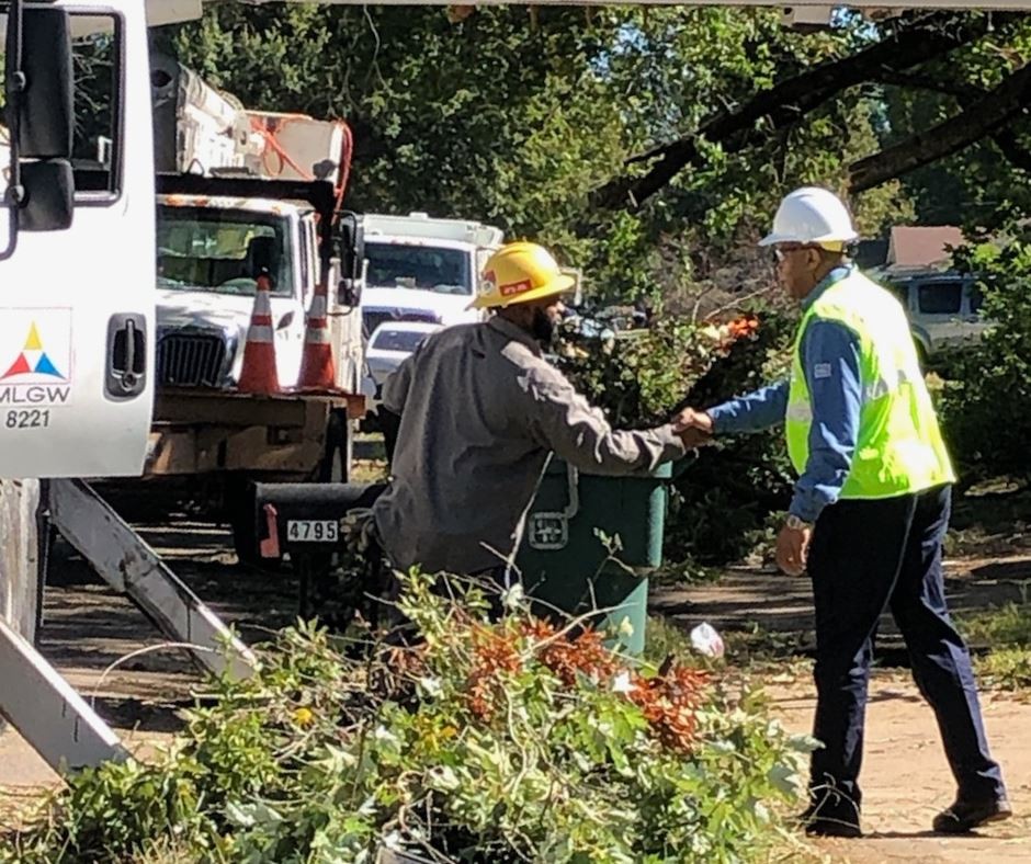
About 9,700 power outage reports remained active statewide as of 11:30 a.m. Thursday, according to TEMA. This is down from more than 15,400 outages reported as of 4 a.m.
Communications systems are experiencing problems in McNairy County and TEMA is working with local officials to remedy the situation.
Customers served by the Grand Junction Water Department in Hardeman County do not have water. The Henderson Water Department in Chester County is under a boil water advisory.
Multiple roads throughout Middle and West Tennessee have been impacted by downed trees and power lines and flooding, according to the Tennessee Department of Transportation (TDOT). Crews are working to clean up debris.
Excessive rainfall to come
Excessive rainfall continued Thursday with the “bullseye” of enhanced risk storms encompassing most of West Tennessee from Memphis to Clarksville along Interstate 40. Widespread flash floods were expected, according to NWS Memphis.
Most areas of Middle and West Tennessee have seen between 3-5 inches of rain over the last 18 hours, with some areas nearing 7 inches, according to TEMA. Another 3-4 inches was forecast for Thursday evening, and 5-7 inches are projected on Saturday.
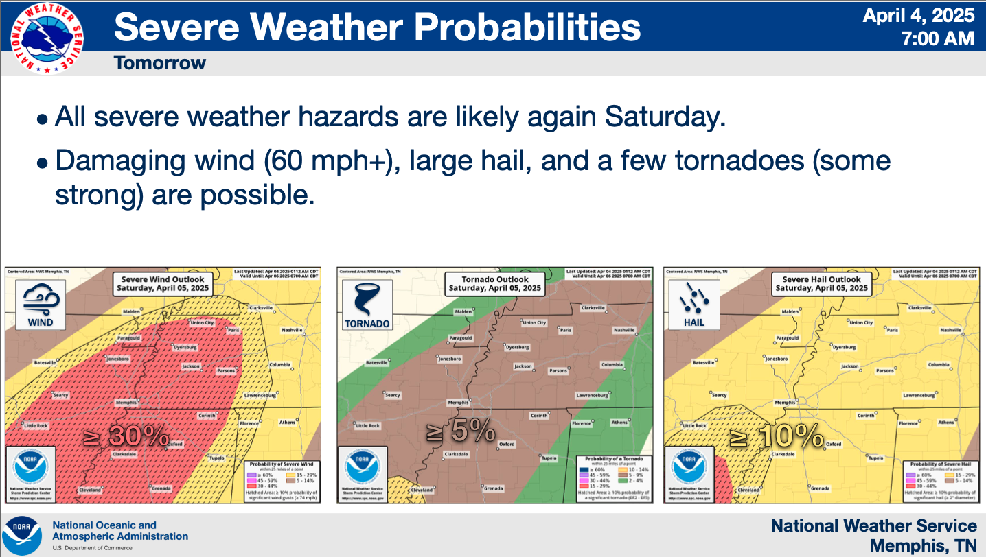
Severe weather forecasts also include continued tornado, large hail and damaging wind threats in addition to flood risks.
This is a developing story.
Tennessee Lookout is part of States Newsroom, a nonprofit news network supported by grants and a coalition of donors as a 501c(3) public charity. Tennessee Lookout maintains editorial independence. Contact Editor Holly McCall for questions: info@tennesseelookout.com.


 MLGW
MLGW 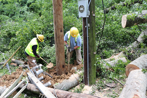 MLGW
MLGW  MLGW
MLGW