“Timing has a lot to do with the outcome of a rain dance.”
That’s a quote by Texas Bix Bender, whom I’d never heard of until accidentally reading this quote online. After extensive research … cough, Google … I learned that Bender writes books with pithy sayings and cowboy humor and lives in Nashville, which is like Texas in that there are lots of cowboy hats — if not as much cattle. But Nashville Bix Bender is a much weaker moniker, so I get it.
Anyway, that aside, I would guess that someone has had very good timing (or bad, depending on your point of view) when it comes to rain dancing, recently. How else to explain the fact that much of the mid-section of the country is under water? The amount of flooding is astonishing — and remarkably widespread.

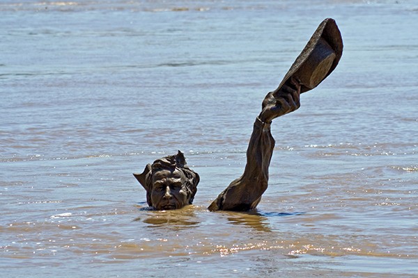
Lewis & Clark statue in St. Louis
Along the upper Mississippi, river towns such as Davenport, Iowa, and Chester, Illinois are inundated. On the Missouri River, many towns in Nebraska, Kansas, and Missouri are flooded. Parts of Nebraska have been dealing with major flooding for more than a month.
In mid-Missouri, the land surrounding the state capital of Jefferson City is under water, and the city is still dealing with the aftermath of a recent devastating tornado. In St. Louis, where the Missouri and Mississippi meet, flood stage is 30 feet. The level of water as I write this on Tueday is 44 feet! The iconic Lewis & Clark statue in downtown St. Louis has disappeared, except for the head and hand of the intrepid (and slightly taller) William Clark. Merriwether Lewis and his trusty dog, Scout, are beneath the deluge.
Meanwhile, over in Arkansas, heavy rain has led to levee breaks along the Arkansas River near Ft. Smith, and much of the area is experiencing, as one local put it, “water in places there has never been water.” Little Rock and other central Arkansas cities are dealing with major flooding. Fortunately, at least, for Memphis, the Arkansas River empties into the Mississippi well downriver from us.
But what’s headed our way down the Mississippi is bad enough. And it will probably get worse. Heavy rain is predicted for the central Midwest over the next few days. From the Weather Channel on Monday: “Many locations from the central and southern Plains into the Mississippi Valley and Ohio Valley could see 1 to 3 inches of rain in the week ahead, with locally up to 5 inches of rain possible in some areas.”
Adding to the misery, the National Weather Service says “a developing tropical storm [Tropical Storm Barry] in the Gulf of Mexico could bring additional rainfall to the region.”
This kind of flooding typically happens in the spring. It’s now June, and the NWS says we can expect the high water to last until the middle of the month and possibly beyond, adding that the flood is already the “longest-lasting since the great flood of 1927.”
It doesn’t appear that Memphis will experience anything near the catastrophic levels of flooding that occurred in 1927 — or even 2011 — but what’s already here is pretty impressive. Flood stage here is around 34 feet. It’s now at 28.5 feet and rising. Don’t plan on walking or biking anywhere between here and West Memphis for a few more weeks. The bottom lands on the other side of the Mississippi bridges are now river-bottom lands — and have been for a couple months.
And, it’s probably raining as you read this, since Memphis was predicted to get thunderstorms for most of the week.
I think I can safely speak for all of us when I say, enough with the damn rain dancing already.