 National Weather Service
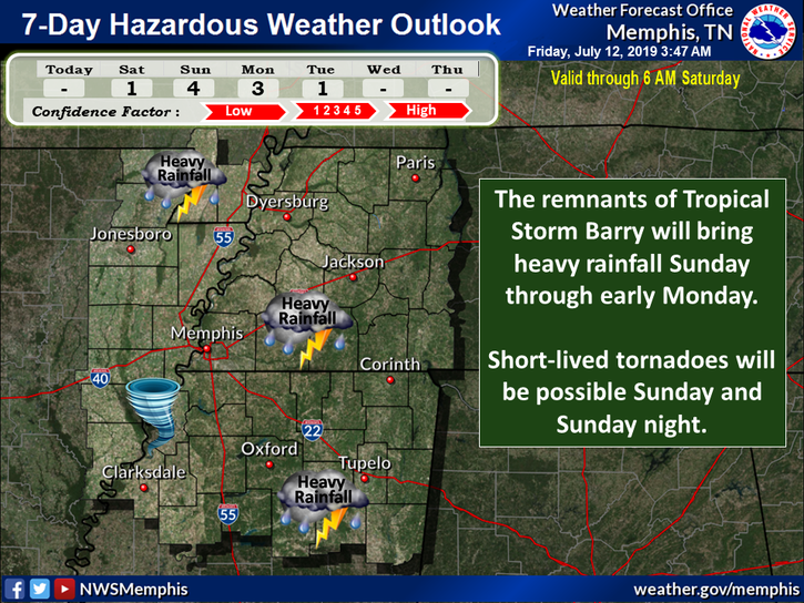
Weather Channel meteorologists now predict rains and wind from Tropical Storm Barry could hit Memphis on Monday.
Barry is now expected to make landfall at the Louisiana coast early Saturday morning. By that time, the storm will likely fall into the high-end tropical storm or low-end hurricane classification, according to The Weather Channel.
“Heavy winds will produce power outages, possible structural damage, and possible tornadoes in the outer bands of the storm,” reads a Friday afternoon notice from The Weather Channel.
The storm will circle New Orleans later that day and move north to hover in northern Louisiana Sunday afternoon.
It will then move through Arkansas and western Tennessee on Monday, according to the channel. The National Weather Service (NWS) at Memphis said 3 to 7 inches of rain could fall between Saturday and Tuesday. Winds of up to 20 to 35 mph are possible, according to the NWS. Isolated tornadoes are also possible on Sunday and Monday. But the main threat to the area, the NWS said, is from rainfall and flooding.
See the latest forecast from Barry here:
Waterlogged River Cities Brace for Barry’s Downpour
Mayors of cities up and down the Mississippi River are preparing for the storm.
The tropical storm threatening the Mississippi River Valley could potentially drop feet of rain on an already flooded region, aggravating flooded conditions by merging existing saturated areas into a large zone of inundation.
“As my friend Mayor Brent Walker of Alton, Illinois, likes to say, we’re getting pretty good at fighting floods since we’re having to do it so often,” Baton Rouge Mayor Sharon Weston Brooms said in a statement. “In 2016, we experienced a 1,000-year rain event here in Baton Rouge that produced a backwater flood situation.
“This time, with the Mississippi River in an extended period of major flooding, we’re looking at the potential of both a back-water and main-stem flood coming together. But we’ve learned from the past and we are better prepared now.”
Along the coast, mayors prepared for high winds, surge, and are depending on new infrastructure built after Katrina.
[pullquote-1] “Our situation along the Gulf near the mouth of the Mississippi River has been improved markedly since 2005,” said Gretna, Louisiana, Mayor Belinda Constant. “We’re banking on those improvements now. What I’m concerned about are the debilitating effects of compounding events on our infrastructure; our spillway has been opened now for the longest time since it was built.
“The 2017 and 2018 hurricane seasons followed by the 2019 prolonged flood all take a toll. We will need to carefully examine impacts and take stock once this storm passes.”
In northern Louisiana, waterlogged cities are bracing for another in what have been back-to-back events.
“I’ve never seen water inundate my city like this,” said Vidalia, Louisiana, Mayor Buz Craft. “Over eight months of flooding is causing seepage at levels we haven’t experienced before. We’re doing all we can to move water out and allow areas to dry. We’ve brought in new partners to help us. But this storm may set us back if it rains enough.”
Long-standing waters in Greenville, Mississippi, are already causing damage assessments to grow and grow there, said Mayor Errick Simmons.
[pullquote-2] “A torrential rain event is not what the doctor ordered at this point,” Simmons said. “The Mississippi River Delta tends to have its own economic challenges without the ongoing disasters.
“Resilience is going to be our driving policy priority for quite some time after this season is behind us.”