Categories
News News Blog News Feature

Damaging Storm Predicted for Memphis Area

Destructive winds, very large hail, and strong tornadoes are possible with a band of storms that could reach the Memphis area overnight.

The National Weather Service predicted the threat of severe storms across the area Wednesday night into Thursday morning. The storm could bring winds up to 80-plus miles per hour, and hail up to 2-plus inches. A flood watch is also in effect. 

“I urge all citizens within the Mid-South area to have multiple ways to receive weather alerts,” said Brenda Jones, director of the Shelby County Emergency Management and Homeland Security Agency. “There are mobile applications for your phone, local news coverage, and/or a NOAA Weather Radio.”

The agency said severe weather that occurs overnight is especially dangerous when tornadoes are involved. Scattered power outages and damage to trees and structures are possible due to damaging winds and lightning. 

The National Weather Service Memphis has been tweeting about the potential for a damaging storm all day Wednesday. The agency went live on Facebook Wednesday afternoon to talk more in depth about the storm. Follow them on X for more details as the storm develops. 

The potential storm canceled the weekly test of the tornado alert system that sounds each Wednesday at 3:30 p.m. 

As of this afternoon, Memphis Light, Gas & Water had not made any public statement about preparations for the storm. However, the utility had retweeted several posts from other agencies, noting that they were aware of the potential of damaging weather.  

Categories
News The Fly-By

MEMernet: Whether to Weather

Memphis on the internet.

Whether to Weather

The National Weather Service of Memphis stunned weather watchers last week with the most accurate forecast ever to be forecasted. “Weather,” tweeted the agency.

The tweet racked up nearly 124,000 views. It also attracted comedian commenters like WMC-TV meteorologist Erin Thomas who wrote, “Big, if true.”


Posted to FAcebook by The Damn Weather of Memphis

The Damn Weather of Memphis (DWM) on Facebook watched a big storm roll in last week. The account predicts weather the best it can but always hilariously hedges.

Of that storm last week, DWM said, “Some model guidance suggests these isolated cells start popping up as early as 11ish and as late as 3ish, with the accuracy of a drunk dart player at your local TJ Mulligans.”

Posted to Twitter by Ty Carpenter

Ty Carpenter tweeted some nightmare fuel out of Eads last week. He said lightning struck a tree there, which caused a gas line underneath the tree to catch fire.

Categories
News News Blog News Feature

Icy Blast Could Bring Power Outages, Hazardous Travel, and Tree Damage

Memphis is bracing for another possible ice storm.

Winter weather warnings were initially only for areas north and south of Memphis. 

But an Ice Storm Warning was later updated to include the entire MidSouth.

The National Weather Service (NWS) in Memphis then predicted possibly two rounds of ice. The first round would come through Monday evening and into Tuesday morning. The next round would come Tuesday evening.  

NWS Memphis Lead forecaster Michael Hill explained it all here:

NWS Memphis warned the storm could cause “power outages, travel difficulties, and tree damage.”

Memphis Light, Gas & Water (MLGW) said Monday afternoon that it was preparing for severe weather. 

“Impacts to the MLGW service area may include power outages, tree damage, and travel difficulties,” MLGW said in a statement. “MLGW crews and additional contract crews are ready to respond to any local damage or outages.”

For all of this, the Facebook page The Damn Weather of Memphis issued a Liquor Store Warning to be in effect until Wednesday morning. It also said the storm is a “solid 6.3 on The Holy Shit Damn Scale.”

(Credit: The Damn Weather of Memphis/Facebook)

“Don’t be a dumbass,” the page said. “The roads will simply look wet, then you come up on an overpass and see an Infiniti on its roof.”

Categories
News News Blog News Feature

Severe Weather, Including Tornadoes, Forecast for Tuesday

Severe weather is forecast for Memphis and the Mid-South Tuesday with tornadoes possible, according to the National Weather Service Memphis (NWSM)

The most severe weather is projected to arrive here tomorrow afternoon and could continue through Wednesday morning. 

“Damaging winds and long-track tornadoes will be possible with highly organized storms,” said NWSM. ”Large hail and flash flooding are also possible, though they are secondary threats.”

On Sunday, the threat raised the area to an Enhanced Risk (orange level, level three of five) for severe storms. On Monday, Memphis was raised to a Moderate Risk (four out of five).

“Moderate Risks are used sparingly and should not be taken lightly,” MNSW said in a tweet. “Take the time to plan and prepare now.”

 In a tweet Sunday, NWSM said “damaging winds, tornadoes, flooding, and large hail are on the table” for Tuesday. “Long-track tornadoes will be possible, and some could be significant,” said the agency. 

Read this tweet thread for detailed information about the storm from MNSW:

NWSM continued to raise the alarm about the threat on Monday.

The Memphis Office of Emergency Management tweeted these tips to get ready: 

Memphis Light, Gas & Water (MLGW) said it is readying crews to “work around the clock” to respond to power outages the storm may cause. 

Categories
At Large Opinion

Big Chill in Bluff City

Two weekends ago, I walked out into the Saturday morning sun. It was 65 glorious degrees and headed into the mid-70s by afternoon. March had just arrived and March means spring in Memphis. And spring in Memphis means it’s time for Yard Man to get after it.

So I rolled the electric mower out of the garage and ran it over the front yard to mulch last October’s standing leaf harvest. Very satisfying. Very mulchy. I could hear the grass giving thanks.

Then I crawled around the flower beds that make up most of our backyard and clipped and snipped the dead stems, marveling at the annual miracle of perennial shoots emerging from the soil, ready for another season of life. I made a large pile of brown vegetation. Also quite satisfying.

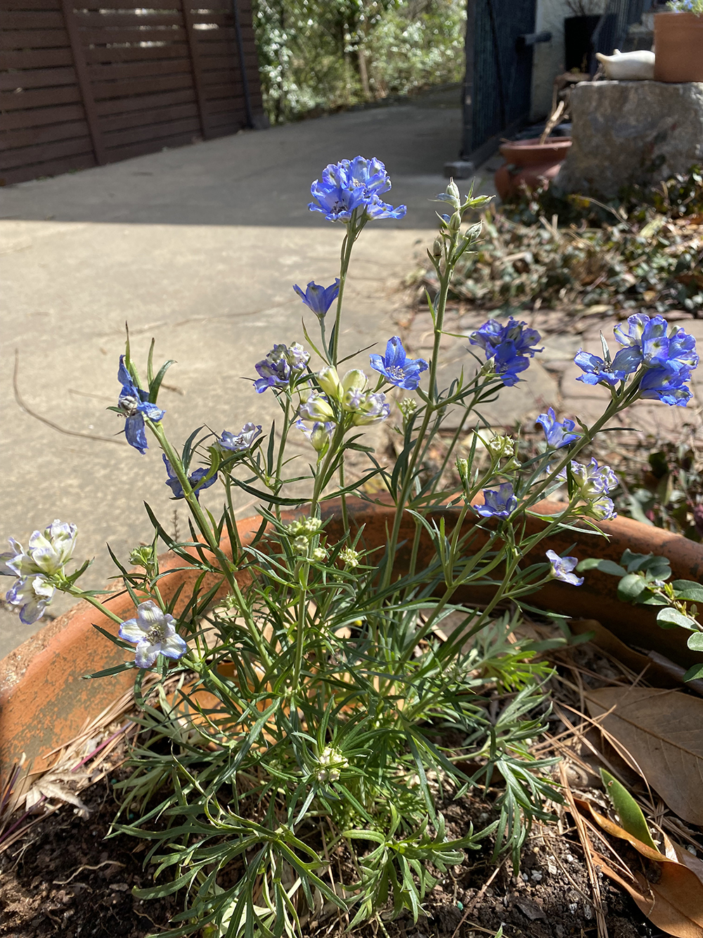
Next, I was drawn like a salmon returning to its home waters, to the Midtown Home Depot, where (as one does) I picked up a mega-package of paper towels, some birdseed for the feeder, six light bulbs, some floor cleaner, two bags of potting soil, and a partridge in a pear tree. And lots of plastic pots of blooming annuals to brighten up the deck — petunias, anemone, lobelia.

There is a clear and simple joy in sitting in the sun and putting fresh plants into old clay pots, digging out last year’s roots and putting the fresh square bundles of soil into their new homes. The smell of loamy earth, the dirty fingernails, the stained trouser knees — all the rituals of spring, of rebirth. 

I liberated the faithful hose from its winter abode and filled it with purpose. The new plants were watered and it was good. Yard Man was content. And there was beer. 

All was well in the kingdom for a couple of days. I took inordinate pleasure from the new flora each time I walked out the back door — the blues, whites, purples, and yellows. I noticed the buds emerging on the fig tree, the white blossoms on the plums, and the big oaks turning green at their tips. Spring was well and truly sprung. 

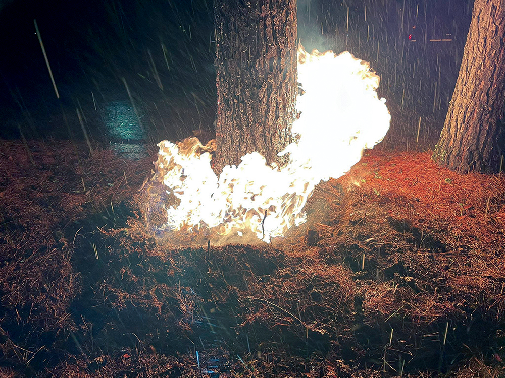
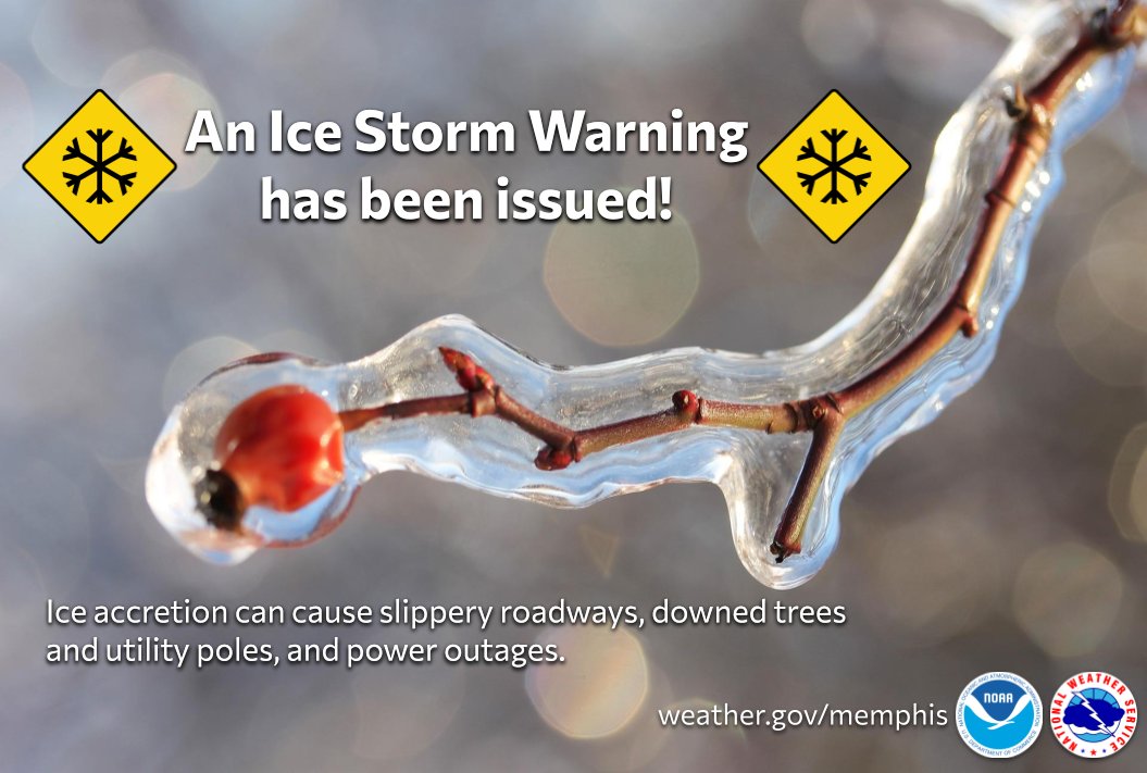
And then we began to hear rumblings of trouble from the West. A cold front was coming, they said, a real one, with ice and snow and frigid temperatures. They were calling the storm a “cyclone bomb” and saying it would hit Memphis Friday night. We’d be lucky to survive, it appeared. The ensuing weekend would be a frozen, snowy, icy mess. In a city that is still littered with piles of limbs from a February ice storm that left 150,000 people without power, this was not good news.

Alas, the storm did arrive Friday night, right on schedule, and it was a doozy, with sleet, lightning, strong winds, freezing rain, four inches of snow, and temperatures in the mid-20s. I built a fire in the fireplace but there was no joy in it. Feeling fatalistic, I decided to just let my new flowers tough it out. Snow would protect them from freezing, I’d heard. Whatever, spring. You bastard. 

The next morning, just one week after I’d welcomed spring to my yard, the city awoke to a coat of thick wet snow. The social-media photos were lovely, folks. Thanks. But there was also sun on this new morning, and lots of it, and before long, rivulets of meltwater were everywhere. Heavy clumps of snow were falling from the trees and rooftops. There were no broken limbs, no power outages. Huzzah.

At midday, I got out in it and walked around the neighborhood, taking in the snowmelt, the wet streets, the bright sun reflecting it all, the warming air. It put me in mind of a John Updike quote that I return to on occasion: “I am now in my amazed, insistent appreciation of the physical world, of this planet with its scenery and weather … that every day and season has its beauty and its uses, that even a walk to the mailbox is a precious experience, that all species of tree and weed have their signature and style and the day is a pageant of clouds.” 

When I returned home I was happy to see that the petunias, anemones, and lobelia were blooming bright in their snow-crusted pots, literally no worse for the weather. And I looked again at the buds emerging on the fig tree, the white blossoms on the plums, the big oaks turning green at their tips. 

Categories
News News Blog News Feature

Ice, Ice, Baby: Memphis Prepares For Frigid Blast

Get prepared and stay off the roads.

That’s the advice of the National Weather Service (NWS) in Memphis. Parts of the MidSouth are now under an ice storm warning as temperatures are expected to fall Wednesday evening and rain turns to sleet.

The NWS does not predict a winter wonderland, however. Forecasters predict sleet and ice for the area instead of snow. Icy precipitation is expected to last through Friday morning. Then, wind chills are expected in the single digits with highs only predicted to be in the mid-to-low 30s.

“Power outages and tree damage are likely where significant ice accumulations occur,” reads a statement from the Shelby County Emergency Management and Homeland Security Agency. “Roads and bridges will become very slick and travel will become very dangerous. [Memphis Light, Gas and Water] crews and additional contract crews are ready to respond to any local damage or outages. However, restoration times may be extended due to Covid-19 safety measures.”

Categories
News News Blog

Heavy Rain, Winds Expected to Hit Memphis

Memphis could get up to six inches of rain and heavy winds as the remnants of Hurricane Ida move through the Mid-South Monday.

The rainfall and winds are expected to begin at 3 p.m. Monday and last through the evening, according to the Memphis National Weather Service. 

Memphis Light, Gas and Water (MLGW) said its crews are prepared to respond to any damage and outages. However, the utility said that restoration times may be longer due to Covid-19 safety measures. 

MLGW also advises the public to avoid contact with downed power lines as the lines could still be active. To report an emergency such as downed wires or gas leaks, call 901-528-4465. For outage reporting, call 901-544-6500. 

Categories
News Blog

“Dangerous Weather” Expected for Memphis

National Weather Service/Twitter

The National Weather Service (NWS) in Memphis said “dangerous weather is expected” for the area Wednesday. 

The area woke to thunder and rain Wednesday. The NWS predicted the possibility for severe weather Tuesday and said hazards could include large hail, damaging winds, and tornadoes. Weather officials here doubled down on the prediction Wednesday morning in a tweet saying, “dangerous weather is expected.  Stay tuned to the latest watch and warning information and be prepared to head to shelter if a warning is issued.”  

The weather threat was enough for city of Memphis officials to cancel all COVID-19 vaccine appointments for Wednesday.

Memphis Light, Gas, and Water (MLGW) said “crews are prepared to handle any outages caused by thunderstorms, damaging winds and a possible tornado headed to the Mid-South.”

For customers to prepare, the utility said they should know where the gas and water shutoff valves are located, how to identify the main electric service panel, and how to turn them off in the event of an emergency. More emergency preparedness information from MLGW can be found here and in this YouTube video. 

MLGW contact information for customers:

• outage reporting: (901) 544-6500

• emergencies: (901) 528-4465 (This number should be treated like 911. Use it to report gas leaks and downed electrical lines.)

• customer care center: (901) 544-6549

• online outage center: www.mlgw.com/outagecenter

To prepare for the severe weather, the Shelby County Emergency Management and Homeland Security Agency issued a list for residents on Tuesday. 

• Listen to NOAA radio for weather alerts.

• Know the alerts

– severe thunderstorm watch: Conditions are favorable. Stay alert! 

– severe thunderstorm warning: Take shelter! Act now! 

– tornado watch: conditions are favorable. Stay alert! 

– tornado warning: A tornado has been seen on radar or reported by a spotter. Take shelter!

• Be prepared to evacuate or shelter-in-place.

• Designate a “safe place” to shelter. Underground is best, such as a basement or storm shelter. If not possible, go to the center room on the lowest floor of a sturdy building.

• If you are in a vehicle, try to seek shelter in a sturdy building. If no building is near, pull over, keep seat belt on. Cover head and neck with your arms and cover your body with a coat or blanket.

• Avoid parking under bridges and overpasses.

• Anticipate power outages.

• Charge cell phones and be sure to have fresh batteries for flashlights.

Also, the weekly tornado siren, which sounds every Wednesday at 3:30 p.m., had been cancelled today:

Here’s what Memphis-area Twitter user Brutus thinks about the weather:

Categories
News The Fly-By

MEMernet: 69 Degrees at 4:20, Fire at Mud Island, and a Free but(t) Loved Couch

Nice

“Memphis was dank earlier today.”

Posted to Reddit by u/jkillz87

No chill, 2020

“Well, the Mud Island Marina is burning down. Par for the course in 2020.”

Posted to Reddit by u/JesusLanaPhrasing

Cheeky Couch

This free couch had been nothing but(t) loved. “Comfy, just needs to be recovered,” reads the curb alert post from Nextdoor last week.

Posted to Nextdoor by Ashton S.

Categories
News News Blog

Hurricane Laura Promises Wet, Windy Weather Ahead

National Weather Service

The National Weather Service at Memphis predicts “business will certainly pick up” around here as soon as Hurricane Laura moves across the Mid-South this afternoon.

Get your umbrellas, folks.

Hurricane Laura Promises Wet, Windy Weather Ahead

Hurricane Laura Promises Wet, Windy Weather Ahead (2)

What can we expect? Check out this two-hour (two-hour!) YouTube video of Laura near Lake Charles.

Live Youtube Stream from Lake Charles from r/NewOrleans

Hurricane Laura Promises Wet, Windy Weather Ahead (4)

But if you want the real weather report, take it from Louisiana’s Ernest Washington.

Ernest Washington here with the Real God Damn Weather Report from r/Louisiana

Hurricane Laura Promises Wet, Windy Weather Ahead (3)